| Time: | 3 days |
| Distance: | 27 km |
| Fitness: | M |
| Skill: | MH |
| Ascent: | 870 m |
| Maps: | LPI Kanangra 8930-3S 1:25000 |
| LPI Yerranderie 8929-4N 1:25000 | |
| Notes: | Print-friendly notes (opens in new window) |
Introduction

Kanangra Creek gorge from up on Kanangra Walls
The Kowmung River is a beautiful, wild river, one of the least impacted by human habitation in the Blue Mountains. This walk visits a section of the Kowmung as it flows through Bulga Denis Canyon. Walkers need to be reasonably fit to cover the almost 900m height change into the gorge. However, done as a three day walk, the total distances aren't great. It can be done in a weekend with an early start, or by walking out to Coal Seam Cave on the Friday night. Some scrambling may be required to descend Cambage Spire.
Access
The walk starts at Kanangra Walls car park. For directions on how to get to Kanangra Walls, see the information on the Kanangra Walls region to the right.
Track notes
From 14 Apr 2006, last checked 14 Apr 2006
Day 1: Kanangra Walls to Cambage Spire to Christys Creek Junction (10km, 840m descent)
From the car park at Kanangra Walls, follow signs to the Plateau Track. Avoid a turn off to the right to Dance Floor Cave and ascend a set of steps on to the plateau proper.
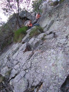
Walkers lowering packs off Cambage Spire
The track out along the plateau crosses a number of rocky clearings, and often splits and rejoins itself. There are numerous places to detour off the track to the cliff edge to the north for fantastic views of the Kanangra Creek gorge, Thurat Spires, and Kanangra Falls. At a large rocky clearing about 1km on to the tops, the trail divides. Neither branch is obvious as the clearing is large. The clearing is just after a short climb from a saddle, and has excellent views from the edge to the north. One branch of the track heads south east towards Maxwell Top, and the other continues east along the main part of the plateau. Take the south east branch, which climbs up to the top of the ridge and then heads south. Avoid a turn off to the left after another kilometre, and continue along the eroded track which drops into a saddle and then climbs to Murrarang Top. Down the other side, the path splits and later rejoins. The right hand path descends down a gully through the cliffline, and around the point. It rejoins the other path at a break in the cliffline on the south side.
Continue along to shortly reach the Coal Seam Cave. This is a large overhang which is often used by parties on the Friday night of a weekend walk. There is often a large plastic drum that collects water that has dripped from the roof of the cave, if there has been recent rain. At the end of the cave, the track drops steeply down to a saddle, where it forks. The right path climbs up the ridge to Cottage Rock. A short scramble leads to the top, from where there are 360° views, including the Gingra Range and Arabanoo Creek, and stretching as far as Byrnes Gap and the Tonalli Tablelands.

A low-lying bluff on the Kowmung River
Return to the main track, which now sidles beneath Cottage Rock before again splitting. The main (left hand) path leads out on to the Gingra Range, which is the track you will return on. The right path, which you should take, leads to the top of a small knoll, with the stumps of a number of trees. From here, a very vague track heads south. Follow the track, navigating carefully along Bullhead Ridge, as the route is vague in places. In particular, note the sharp right hand turn as you reach the top of Bullhead Mountain. The far side of Bullhead Mountain has good views and is a nice spot for lunch.
The path drops steeply to a saddle, and after a short climb you reach the rocky top of Cambage Spire. From here the route looks quite improbable, a steep scrambly section leading to precipitous cliff. However, there are several routes leading to the bottom. The easiest heads down the right hand side, traversing back left to the main ridge once the cliff ends. A more challenging route heads straight down the ridge line (some scrambling), and cuts back left sharply into a small gully. Some more scrambling is needed to descend the gully, and rope is useful for passing packs. Once at the bottom, regain the main ridge.
The rest of the route to the Arabanoo Creek - Kowmung River junction is steep and a bit loose, but navigation is relatively straightforward. The route generally remains close to the main line of the ridge. Some more easy scrambling may be required.
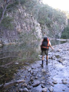
Walkers heading downstream on the Kowmung through Bulga Denis Canyon
At the junction, there are a couple of campsites. One is at the base of the spur that you descend, the other about 50m upstream on the Kowmung, across Christys Creek. Unfortunately there are a lot of cobbler's pegs (Bidens pilosa) in the area. There are other campsites further down the Kowmung, but these are among the best in the near vicinity.
Day 2: Christys Creek Junction to Orange Bluff (7km, 30m descent)
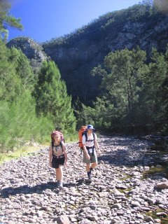
The next day, head downstream along the Kowmung. If the water levels are low, you may be able to keep your feet reasonably dry. Otherwise, you will almost certainly need to wade a few times to avoid riverside bluffs. There are a few campsites in the gorge, although a number of the flat sections have been invaded by weeds, mainly blackberry, cobbler's pegs and stinging nettles.
There are plenty of places to stop and have a swim if the weather is warm enough.
There is a large grassy area at the foot of Brumby Ridge, opposite Orange Bluff, which is a popular camp site, and convenient for the walk out the next day.
Day 3: Orange Bluff to Kanangra Walls via Brumby Ridge (10km, 870m ascent)
On the final day, find the faint track leading up Brumby Ridge to First Top Mountain. This is a steady climb with occasional views. Just past First Top, the track meets the Gingra Range track. Follow this back to where you turned off to Bullhead Ridge on the first day, and make your way back to the car park at Kanangra Walls.
Alternatively you could head further downstream and ascend to the Gingra Range via Roots Ridge, which also has a faint track.
Keeping your feet dry on a shallow crossing of the Kowmung
Related walks
Kanangra to Carlon's Farm (Green Gully)
Time: 3 days Distance: 36 km Fitness: M Skill: M Ascent: 1380 m
A variant on one of the classic Blue Mountains walks - finishing at Carlon's Farm below Blackheath, rather than at Katoomba
Kanangra to Katoomba
Time: 3 days Distance: 45 km Fitness: MH Skill: M Ascent: 1350 m
An excellent crossing of the southern Blue Mountains with a variety of scenery
Cottage Rock
Time: 4 hrs Distance: 9 km Fitness: E Skill: EM Ascent: 160 m
A relatively easy day walk with excellent views at a number of points along the way.
Gingra Range
Time: 2 days Distance: 36 km Fitness: MH Skill: EM Ascent: 890 m
A long but fairly straightforward walk out to the junction of the wild Kowmung River with Gingra Creek
Hatchers Hollow
Time: 2 days Distance: 24 km Fitness: MH Skill: MH Ascent: 840 m
A challenging walk to this excellent campsite on the picturesque Kowmung River
Orange Bluff
Time: 2 days Distance: 22 km Fitness: EM Skill: EM Ascent: 850 m
The shortest walk from Kanangra Walls to the scenic Kowmung River, with an excellent campsite below the towering Orange Bluff
Brumby and Hughes Ridges
Time: 2 days Distance: 30 km Fitness: MH Skill: M Ascent: 850 m
A harder walk in the upper reaches of the beautiful lower Kowmung River.
Personal reports
14-16/04/2006 - Bulga Denis Canyon: Kanangra Walls - Bullhead Mountain - Cambage Spire - Christy's Creek (C) - Kowmung River - Orange Bluff (C) - Brumby Ridge - Kanangra Walls (report | photos)
Links
 Classic Blue Mountains Walks (Wild Guide), David Noble
An excellent guide for the more experienced walker, as it suggest a number of walks not covered by other guides.
 Bulga Denis Canyon - James Bevan (SUBW)
Report of a trip through Bulga Denis Canyon, approaching via Arabanoo Creek.