| Time: | 4 hrs |
| Distance: | 9 km |
| Fitness: | E |
| Skill: | EM |
| Ascent: | 160 m |
| Maps: | LPI Kanangra 8930-3S 1:25000 |
| LPI Yerranderie 8929-4N 1:25000 | |
| Notes: | Print-friendly notes (opens in new window) |
Introduction
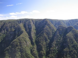
Thurat Spires, on the right, are distinctive amongst the deep gullies of Kanangra Gorge
Cottage Rock is a large sandstone outcrop just south of Kanangra Walls. From its flat top it offers superb views of the southern Kanangra-Boyd National Park. It can be reached by a relatively easy day walk from the Kanangra Walls car park.
Access
The walk starts at Kanangra Walls car park. For directions on how to get to Kanangra Walls, see the information on the Kanangra Walls region to the right.
Track notes
From 14 Apr 2006, last checked 31 Jul 2016
From the car park at Kanangra Walls, follow signs to the Plateau Track. Avoid a turn off to the right to Dance Floor Cave and ascend a set of steps on to the plateau proper.
The track out along the plateau crosses a number of rocky clearings, but is fairly wide, obvious and well-maintained. However, you should be heading in a generally easterly direction. There are numerous places to detour off the track to the cliff edge to the north for fantastic views of the Kanangra Creek gorge, Thurat Spires, and Kanangra Falls.
At a large rocky clearing about 1km on to the tops (GR341357), the trail divides. Neither branch is obvious as the clearing is large. The clearing is just after a short climb from a saddle, and has excellent views from the edge to the north, and is some 50m long and 10-20m wide. One branch of the track leaves from south eastern end of the clearing, heading initially north east, then south towards Maxwell Top. The other leaves from the northern side of the clearing, heading north east along the main part of the plateau. Take the south east branch, which climbs up to the top of the ridge and then heads south. Avoid a turn off to the left after another kilometre, and continue along the eroded track which drops into a saddle and then climbs to Murrarang Top. Down the other side, keep left at a fork, and shortly descend via a small scramble through a break in the cliffline at GR344338.
Make a note of the descent spot for the return trip.
Continue along to shortly reach the Coal Seam Cave after a few minutes. This is a large overhang which is often used by parties on the Friday night of a weekend walk. At the end of the cave, the track drops steeply down to a saddle, where it forks (GR347337), possibly with a cairn marking the junction.
Take the fainter right hand path, which climbs up a short ridge to Cottage Rock. A short scramble leads to the top, from where there are 360° views. The Gingra Range and Arabanoo Creek are distinctive features, and you should be able to follow the path of the Kowmung as it winds its way through Bulga Denis Canyon. With the help of a map, you should also be able to spot Mt Marrup, Kowmung Mountain and Byrnes Gap in the distance, as well as Mt Colboyd and Mt Bulgin a little closer.
After a decent break, make your way back to Kanangra Walls by the same route.
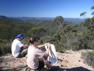
Walkers survey Gingra Creek and the Gingra Range from the top of Cottage Rock
Related walks
Bulga Denis Canyon
Time: 3 days Distance: 27 km Fitness: M Skill: MH Ascent: 870 m
An excellent walk showing off the great variety of scenery in Kanangra-Boyd NP.
Hatchers Hollow
Time: 2 days Distance: 24 km Fitness: MH Skill: MH Ascent: 840 m
A challenging walk to this excellent campsite on the picturesque Kowmung River
Orange Bluff
Time: 2 days Distance: 22 km Fitness: EM Skill: EM Ascent: 850 m
The shortest walk from Kanangra Walls to the scenic Kowmung River, with an excellent campsite below the towering Orange Bluff
Brumby and Hughes Ridges
Time: 2 days Distance: 30 km Fitness: MH Skill: M Ascent: 850 m
A harder walk in the upper reaches of the beautiful lower Kowmung River.
Kanangra to Carlon's Farm (Green Gully)
Time: 3 days Distance: 36 km Fitness: M Skill: M Ascent: 1380 m
A variant on one of the classic Blue Mountains walks - finishing at Carlon's Farm below Blackheath, rather than at Katoomba
Kanangra to Katoomba
Time: 3 days Distance: 45 km Fitness: MH Skill: M Ascent: 1350 m
An excellent crossing of the southern Blue Mountains with a variety of scenery
Gingra Range
Time: 2 days Distance: 36 km Fitness: MH Skill: EM Ascent: 890 m
A long but fairly straightforward walk out to the junction of the wild Kowmung River with Gingra Creek
Personal reports
11-12/05/2013 - Compagnoni Pass: Kanangra Walls - Coal Seam Cave - Cottage Rock - Gingra Range - Kowmung River - Gingra Creek - Willa Spur (C) - Compagnoni Pass - Ti Willa Plateau - Mt Cloudmaker - Gangerang Range - Gordon Smith Pass - Kanangra Walls : the weather was absolutely gorgeous, so it was amazing that there was no-one else doing any overnight walks this weekend at Kanangra (report | photos)
Links
 Bushwalks in the Sydney Region Vol 1 (Edition 4), S Lord and G Daniel
An excellent resource for walkers, with a variety of walks within easy reach of Sydney