| Time: | 2 days |
| Distance: | 24 km |
| Fitness: | MH |
| Skill: | MH |
| Ascent: | 840 m |
| Maps: | LPI Kanangra 8930-3S 1:25000 |
| LPI Yerranderie 8929-4N 1:25000 | |
| Notes: | Print-friendly notes (opens in new window) |
Introduction

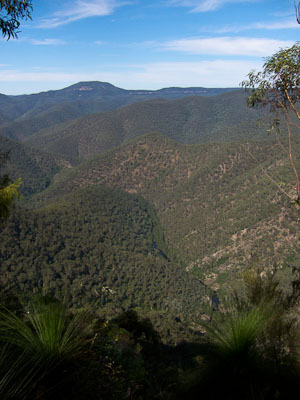
Views of the Kowmung River and Mt Colong from Dicksonia Bluffs
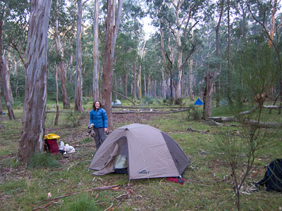
Hatchers Hollow is an idyllic valley nestled between small hills in the upper to middle part of the Kowmung River. Its grassy flats stretch for almost half a kilometre between the river and Redcliff Creek, and make for great camping. It is infrequently visited as it is difficult to access, but a visit is well worthwhile as you are likely to have it to yourself.
Routes to Hatchers Hollow typically involve a long ridge walk, and a crossing of, and short walk along the Kowmung River. The route suggested in these notes is one of the shorter ways in and out. There are many others.
While summer is a great time for swimming in the river, the long ridge walk and steep climb makes it an arduous time of year to visit. Winter involves a chilly crossing of the Kowmung. The best times are probably mid-to-late autumn, and spring. Be wary of walking if there has been significant rain as the Kowmung needs to be forded to reach Hatchers Hollow.
Access
The walk starts at the trackhead for the Uni Rover Trail at Kanangra.
To get there, drive to the Boyd River Campground (directions under the Kanangra Walls region to the right). Continue past the campground for 2km. Turn right on to the signposted Morong Creek Trail (formerly Boyd River Fire Trail), also signposted to the Uni Rover Trail. This section of the fire trail is normally 2wd accessible, though there are some large potholes and occasional muddy section where care needs to be taken. Drive along this for 1.5km to a large signboard marking the start of the Uni Rover Trail and park off the road.
Track notes
From 07 May 2011, last checked 31 May 2014

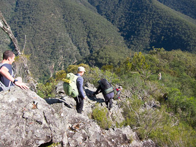
Descending Sombre Buttress
Much of the walk by distance follows the Uni Rover Trail, which meanders its way across the plateau to the Boyd Range and down to the Kowmung at Lannigans Creek. The track was marked originally in the early 1960s by the Sydney Uni Rover Crew, hence the name. The track itself is well worn in some places, and almost non-existent in others. There are white tags in places along the track, though these are not always obvious. The first 4km out to Mt Goondel can be particularly hard to follow, as the track does not follow natural features.
The walk is almost entirely in the Kanangra-Boyd Wilderness Area, so track notes are less detailed than usual. Parties should be proficient in their navigation as tracks are vague.
Once on the Boyd Range proper, water is hard to come by without dropping a long way down. Prior to the Boyd Range there are a few possible places where water may be obtained, provided it has not been too dry. Most useful is likely to be the small creek crossing about 200m beyond Lost Rock. On the return journey, if you cross Illusive Gully on the way to Mt Hopeless, there is likely to be water, which will save carrying it all from the Kowmung River.
Day 1: Morong Creek Trail - Hatchers Hollow via Uni Rover Trail and Mt Savage (13km, 840m descent)
Start by following the Uni Rover Trail out to Lost Rock. This part of the track traverses the open forests and grassy flats of the Boyd Plateau, with one short section crossing the outlet of Hodges Swamp at a small creek. Wet feet here are a possibility, though some logs provide a potential dry option. Continue through more open forest for 1.5km (about 25 minutes) where a rocky clearing on your left opens out to views across the Kowmung Valley. This is Lost Rock, and offers great views all the way to the distinctive flat top of Mt Colong.

Idyllic campsite at Hatchers Hollow
Heading generally SSE, a small creek is crossed, and then a short section of swamp, where again wet feet are a possibility. There is a nice campsite on the left just before the swamp. The track then climbs to Mt Goondel, the start of the Boyd Range. From Mt Goondel, the track follows the ridge generally SE, and the ridges are much more distinct. The walking is fairly easy, and open for the most part to Mt Savage.
From Mt Savage, leave the track and navigate S to Sombre Dome, and down to Dicksonia Bluffs for excellent views. This is a good spot for lunch if you are there in time. Follow the steep rocky ridge down to the W to the junction of Doris Creek and the Kowmung River. There is some easy scrambling and plenty of loose rocks on the ridge, and it gets a little scrubby near the bottom.
At the river, cross Doris Creek and continue along the bank until the river is shallow enough to cross below a large riverside bluff. Continue upstream on the other bank keeping near the river, crossing the first gully (Hatchers Gully) before walking up the next gully and into Hatchers Hollow, which is set a little way back from the river.
Day 2: Hatchers Hollow - Morong Creek Trail via Mt Misery and Uni Rover Trail (11km, 840m ascent)
The next morning retrace your steps back to Doris Creek. Head upstream for 100m or so until you can climb up on to the ridge on your left. The ridge is steep, and some meandering and scrambling is needed to work your way up through broken clifflines. The ridge eventually relents and you reach the summit of Mt Doris. Follow the ridge over Mt Ibbai and Mt Despond and along Despond Ridge to a small saddle just above Illusive Gully. There are excellent views from the western slopes of Mt Ibbai, as well as from various points on Wedgetail Bluffs below the slopes of Mt Despond.
Cross Illusive Gully and scramble up to Mt Hopeless, and from there walk up Mt Misery and navigate back to the Uni Rover Trail at Mt Goondel. Retrace your steps back to the cars at the start of the Uni Rover Trail.

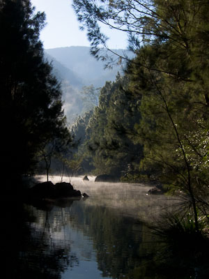
Morning mist on the Kowmung
Related walks
Bulga Denis Canyon
Time: 3 days Distance: 27 km Fitness: M Skill: MH Ascent: 870 m
An excellent walk showing off the great variety of scenery in Kanangra-Boyd NP.
Kanangra to Carlon's Farm (Green Gully)
Time: 3 days Distance: 36 km Fitness: M Skill: M Ascent: 1380 m
A variant on one of the classic Blue Mountains walks - finishing at Carlon's Farm below Blackheath, rather than at Katoomba
Kanangra to Katoomba
Time: 3 days Distance: 45 km Fitness: MH Skill: M Ascent: 1350 m
An excellent crossing of the southern Blue Mountains with a variety of scenery
Cottage Rock
Time: 4 hrs Distance: 9 km Fitness: E Skill: EM Ascent: 160 m
A relatively easy day walk with excellent views at a number of points along the way.
Gingra Range
Time: 2 days Distance: 36 km Fitness: MH Skill: EM Ascent: 890 m
A long but fairly straightforward walk out to the junction of the wild Kowmung River with Gingra Creek
Orange Bluff
Time: 2 days Distance: 22 km Fitness: EM Skill: EM Ascent: 850 m
The shortest walk from Kanangra Walls to the scenic Kowmung River, with an excellent campsite below the towering Orange Bluff
Personal reports
31/05-01/06/2014 - Doris Creek: Uni Rover Trail - Lost Rock - Mt Goondel - Doris Creek - Goondel Falls - Hidden Falls - Doris Falls - Kowmung River - Hatchers Hollow (C) - Mt Doris - Mt Ibbai - Mt Despond - Despond Ridge - Illusive Gully - Mt Hopeless - Mt Misery - Mt Goondel - Lost Rock - Uni Rover Trail [SBW]: Alex, Nicole and Kerry walked in via Sombre Dome, but we all walked out together on Sunday (report | photos)
07-08/05/2011 - Hatchers Hollow: Morong Creek Trail - Uni Rover Trail - Lost Rock - Mt Goondel - Mt Savage - Sombre Dome - Dicksonia Bluffs - Sombre Buttress - Doris Creek - Kowmung River - Hatchers Hollow (C) - Kowmung River - Doris Creek - Mt Doris - Mt Despond - Doris Creek - Mt Hopeless - Mt Misery - Mt Goondel - Lost Rock - Uni Rover Trail - Morong Creek Trail [SBW] (photos)