| Time: | 5 hrs |
| Distance: | 17 km |
| Fitness: | M |
| Skill: | EM |
| Ascent: | 410 m |
| Maps: | LPI Kurrajong 9030-4N 1:25000 |
| LPI Springwood 9030-4S 1:25000 | |
| Sketch maps: | Sketch map 1 PDF |
| Notes: | Print-friendly notes (opens in new window) |
Introduction

The Grose River from high above at Faulconbridge Lookout
While the upper Grose River is regularly visited by people heading for the Blue Gum Forest and surrounds, the lower Grose is often forgotten. This is a pity, as in many ways it is more wild and less touched than some of the upper sections. This walk follows a fire trail and old walking track down to a beautiful swimming hole. It is best in late spring, so that the ridge walk in is not too hot, but the weather is still inviting enough for a swim at the bottom. Late spring also means that some of the wildflowers will still be out.
Access
Heading west along the Great Western Highway, turn right into Grose Rd at Faulconbridge (the turnoff to the Norman Lindsay Gallery). Veer left at a roundabout, and continue along the road until you hit the dirt. The dirt road reaches a locked gate about 2.5km after the turnoff from the Highway.
You can catch a train to Faulconbridge Station, and walk from there, but this adds about 2.5km each way.
Mountain bikes can also be used from Faulconbridge Station, and in fact could be used along the fire trail as well. The walking track to the Grose is about 2km each way.
Track notes
From 14 Nov 2004, last checked 15 Jul 2011
From the locked gate, head north along the fire trail. This is pleasant and easy walking, with minimal ups and downs. In summer, baby mountain dragons skitter across the path at your approach.

A beautiful swimming hole at the foot of the walking track
Keep an eye out for the track down to the Grose River. It is about 5.5km from the car park, and is on a slight uphill, at the same point as an old bulldozer track. It heads roughly north east. Continue past it for now for a further kilometre along the fire trail to the lookout, with fantastic views as the Grose River sweeps through a large bend below you. After a break, return back to the turnoff and take the track down to the Grose.
The track winds steeply down, although not as steeply as marked on the topo map. It crosses the creek several times and then flattens out, before dropping very steeply to the river. There are two short climb downs in the last section, and it would be advisable to get a confident scrambler to go down first and help others down. You may want a short rope.
At the bottom is a beautiful large pool. A large flat rock makes a great spot for lunch, or swim over to other rocks for a spot in the sun. Water should be ok to drink from the stream that joins at the bottom, as the catchment is entirely inside the national park. If it is dry, you can take water from the Grose, but it should be treated before drinking.
After a leisurely lunch and a swim, return the way you came.
The walk can also largely be done as a mountain bike ride, from Faulconbridge Station to the lookout. Lock bikes at the top of the walking track to the Grose, or hide them in the bushes.
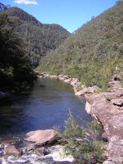
The Grose River downstream from the swimming hole
Related walks
Rigby Hill
Time: 1 hr Distance: 2 km Fitness: E Skill: E Ascent: 60 m
An easy and short walk to a fantastic lookout over the Grose Valley.
Hanging Rock and Baltzer Lookout
Time: 4 hrs Distance: 11 km Fitness: E Skill: E Ascent: 100 m
An easy walk to the impressive Hanging Rock near Blackheath, and to Baltzer Lookout over the Grose Valley
Lockley Pylon
Time: 2 hrs Distance: 7 km Fitness: E Skill: E Ascent: 40 m
An easy walk to impressive views over the Grose Valley and Govetts Gorge.
Magdala Creek
Time: 4 hrs Distance: 11 km Fitness: EM Skill: EM Ascent: 200 m
A pleasant summer walk along shady paths, with a short climb to a good lookout.
Blue Gum Forest via Evans Lookout and Perrys Lookdown
Time: 2 days Distance: 22 km Fitness: M Skill: EM Ascent: 750 m
The classic walk into the Blue Gum Forest, with camping on grassy flats under the magnificent blue gums
Mt Banks
Time: 5 hrs Distance: 15 km Fitness: EM Skill: EM Ascent: 200 m
A climb of one of the prominent peaks of the Blue Mountains, with excellent views of the Grose Valley from its slopes.
Victoria Falls
Time: 2 hrs Distance: 4 km Fitness: E Skill: E Ascent: 360 m
A short but steep walk to a series of pretty cascades on Victoria Creek.
Glenbrook to Springwood
Time: 7 hrs Distance: 21 km Fitness: M Skill: EM Ascent: 530 m
An excellent walk in the lower Blue Mountains following both ridges and creeks.
Blue Gum Forest via Du Faur Head
Time: 6 hrs Distance: 12 km Fitness: M Skill: EM Ascent: 650 m
A challenging and scenic route in to the Blue Gum Forest
Pierces Pass
Time: 6 hrs Distance: 15 km Fitness: EM Skill: EM Ascent: 540 m
A steep descent to the Grose River through a delightful rainforest ravine, with a visit to the magnificent Blue Gum Forest.
Grose Head South
Time: 5 hrs Distance: 15 km Fitness: EM Skill: E Ascent: 350 m
An easy walk to the highest peak on the south side of the Lower Grose, and some spectacular lookouts.
South Lawson Waterfalls
Time: 5 hrs Distance: 12 km Fitness: EM Skill: E Ascent: 210 m
Mostly easy walking on fire trails and tracks to a number of waterfalls - spectacular after rain
Personal reports
06-07/04/2019 - Wentworth Cave: Grose Rd - Faulconbridge Ridge FT - Grose River Walking Track - Grose River - Linden Creek (C) - Wentworth Cave - Linden Creek - Faulconbridge Ridge - Faulconbridge Point - Faulconbridge Ridge FT - Grose Rd (photos)
15/07/2011 - Faulconbridge Point: Faulconbridge Ridge - Grose Valley Walking Track - Grose River - Linden Creek - Faulconbridge Point - Lookout - return to car via Faulconbridge Ridge [Bush Club][L] (photos)
14/11/2004 - Lower Grose River: Faulconbridge Ridge - Faulconbridge Lookout - Grose River Walking Track - Springwood Creek - Grose Mountain Lookout - Blue Gum Swamp Creek - Winmalee (report | photos)
Links
 Bushwalks in the Sydney Region Vol 2 (Edition 3), S Lord and G Daniel
An excellent resource for walkers, with a variety of walks within easy reach of Sydney
 Faulconbridge Point - the fat hippy's Blue Mountains Mountain Bike Rides
Notes for the bike ride to Faulconbridge Point