| Time: | 4 hrs |
| Distance: | 11 km |
| Fitness: | E |
| Skill: | E |
| Ascent: | 100 m |
| Maps: | LPI Mount Wilson 8930-1N 1:25000 |
| Notes: | Print-friendly notes (opens in new window) |
Introduction
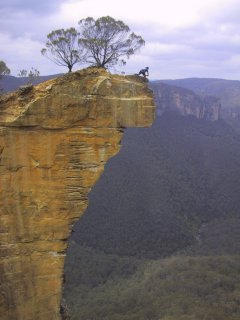
An adventurous person on the end of Hanging Rock, overlooking the Grose Valley
Hanging Rock is a outstanding feature near Baltzer Lookout, at the end of Ridgewell Road, Blackheath. A huge, overhanging block of sandstone over 100m high, jutting out into the Grose Valley, has become detached from the main cliff. It has featured in many calendars and climbing photos, and was also the site of the main climbing scene in "The Edge" movie.
Access
Heading west along the Great Western Highway, turn right on to Ridgewell Rd, 800m after the main traffic lights in Blackheath. Follow the dirt road for 0.8km until you reach a locked gate. Park here.
If walking from Blackheath Station, it is 600m to the Ridgewell Rd turnoff. Walking from and to the station adds 3km to the overall walk.
Track notes
From 14 Sep 2004, last checked 14 Sep 2004
As the walk to Baltzer Lookout is almost entirely on fire trail, this could easily be ridden with mountain bikes.
Reaching the lookout is quite straightforward as it just involves following the main fire trail. There are several lesser fire trails that branch off in the first couple of kilometres, but the main trail is fairly obvious. After 1.6km, you pass the old National Parks gate. There are a few small uphills and downhills, but it's mostly relatively flat. At the end of the road, there is a small fence, and the lookout is through the gate at the top of the hill.
From the lookout there are superb views up and down the Grose Valley. If you look down to your left, you can see Hanging Rock
Follow a steep track down to the left which leads to even better views of Hanging Rock. For those who are fearless, you can even jump across the gap on to the Rock itself. However, you do so at your own risk - a slip could prove fatal.
After a break, return the way you came to your car.
Related walks
Rigby Hill
Time: 1 hr Distance: 2 km Fitness: E Skill: E Ascent: 60 m
An easy and short walk to a fantastic lookout over the Grose Valley.
Lockley Pylon
Time: 2 hrs Distance: 7 km Fitness: E Skill: E Ascent: 40 m
An easy walk to impressive views over the Grose Valley and Govetts Gorge.
Blue Gum Forest via Evans Lookout and Perrys Lookdown
Time: 2 days Distance: 22 km Fitness: M Skill: EM Ascent: 750 m
The classic walk into the Blue Gum Forest, with camping on grassy flats under the magnificent blue gums
Faulconbridge Ridge to the Grose River
Time: 5 hrs Distance: 17 km Fitness: M Skill: EM Ascent: 410 m
A longish day walk to visit a great lookout and a beautiful swimming hole
Mt Banks
Time: 5 hrs Distance: 15 km Fitness: EM Skill: EM Ascent: 200 m
A climb of one of the prominent peaks of the Blue Mountains, with excellent views of the Grose Valley from its slopes.
Victoria Falls
Time: 2 hrs Distance: 4 km Fitness: E Skill: E Ascent: 360 m
A short but steep walk to a series of pretty cascades on Victoria Creek.
Grand Canyon Loop
Time: 4 hrs Distance: 7 km Fitness: E Skill: EM Ascent: 240 m
An excellent walk showcasing a variety of the best scenery in the Blue Mountains.
Govetts Leap and the Horse Track
Time: 7 hrs Distance: 13 km Fitness: M Skill: EM Ascent: 630 m
Visit some of the most spectacular parts of the Grose Valley on this challenging but rewarding walk.
Blue Gum Forest via Du Faur Head
Time: 6 hrs Distance: 12 km Fitness: M Skill: EM Ascent: 650 m
A challenging and scenic route in to the Blue Gum Forest
Popes Glen and Braeside Tracks
Time: 3 hrs Distance: 9 km Fitness: E Skill: E Ascent: 170 m
A pleasant and easy walk with spectacular views
Colliers Causeway
Time: 4 hrs Distance: 9 km Fitness: E Skill: EM Ascent: 200 m
A walk with lots of variety around and under the cliffs on the west side of Blackheath
Asgard Plateau
Time: 7 hrs Distance: 17 km Fitness: EM Skill: M Ascent: 350 m
Superb views of the upper Grose Valley, and a good mix of on track and easy off track walking in this less visited area
Personal reports
14/09/2004 - Baltzer Lookout: (photos)
Links
 Blackheath For Beginnings - Allan Wells
Good description of a number of walks in the Blackheath region
Hanging Rock and Baltzer Lookout - Wild Walks
Track notes for Hanging Rock and Baltzer Lookout walk