| Time: | 4 hrs |
| Distance: | 9 km |
| Fitness: | E |
| Skill: | EM |
| Ascent: | 200 m |
| Maps: | LPI Katoomba 8930-1S 1:25000 |
| Notes: | Print-friendly notes (opens in new window) |
Introduction
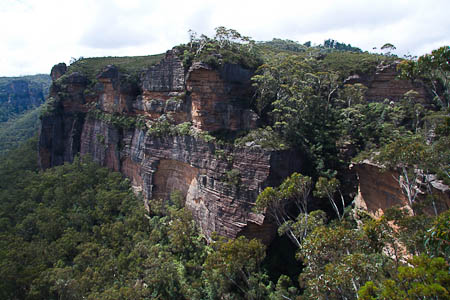
Colliers Causeway from above Walls Ledge
Most visitors to Blackheath are wowed by the tracks in and around the Grose Valley. The tracks on the western side of Blackheath get less attention, which is a pity. Colliers Causeway is one of the less well publicised tracks, and is quite spectacular in its own right. Passing along ledges, under waterfalls and on top of cliffs, it offers a great deal of variety in a short distance.
Access
The walk starts from Blackheath Station.
Track notes
From 19 Feb 2010, last checked 22 Jan 2022
Exit on the west side (Station St side) of Blackheath Station, and walk south to the railway crossing. Turn right into Bundarra St and follow this down to where it ends. A foot track begins here and heads down to cross over a small creek, and up the other side to a track junction.
It is a worthwhile side trip of 100m or so up to Fort Rock, a rocky outcrop that can be climbed and provides good views of the valley. Return to the junction and take the other branch, which leads down into Centennial Glen. This section of track is steep, a bit slippery, and extremely eroded, so take care. Once below the cliffs, the track follows along the cliffline on the left hand side, past a climbing area, and behind a small waterfall. A turnoff to the right is reached that takes you down into the bottom part of Centennial Glen, but ignore this for now.
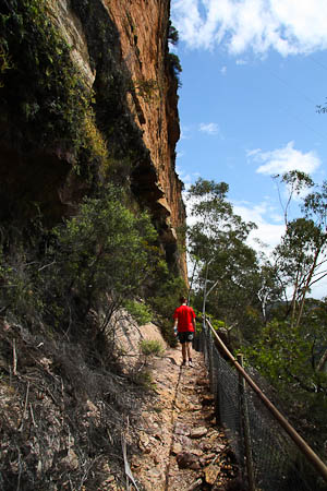
The narrow Walls Ledge track
Continue instead straight ahead, passing another minor turn off, before you reach a track junction. Left heads up to Centennial Glen road, right heads along to Walls Ledge. Take the right branch to Walls Ledge. Walls Ledge is an interesting track that follows the halfway ledge between the upper and lower cliffs of the Shipley Plateau. It is very narrow, and would be quite exposed without the fence. The track also passes through another climbing area, which can get quite busy on weekends. At the end of the ledge the track climbs up and on to the tops. The tops are windswept, covered with low heath, and offer great views. Eventually you arrive at Centennial Glen Road where you can return to the Walls Ledge turnoff. There are some nice little pagodas and views on the way down.
From this junction, returning to one of the previous track junctions. The two tracks head down into Centennial Glen, and join after a short distance. Then there is a steep set of stone stairs that lead down into the creek proper. A sign to the right points to the canyon, which is very pretty and worth a look. If you continue down the creek, it is also a sort of a micro canyon. There are more steep stone stairs which lead down past a large waterfall. Then the track crosses over the creek and heads under the cliffline along Porters Pass. A fair bit of up and down follows, and some bits of track along Porters Pass are somewhat eroded. Towards the end the ledge narrows and there is a slightly exposed section to cross into the creek proper at Porters Pass.
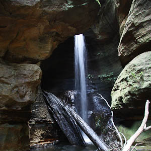
The Grotto, in Centennial Glen
At Porters Pass follow the track as it crosses over two small creeks, climbs up a bit, crosses back over one of the creeks and into a small canyon/glen which is quite pretty. Head up the glen for a short way before climbing out via a steep set of stairs. A short way up the track out there's a side track out to a lookout, over the creeks of Porters Pass from a rocky outcrop, which is well worth visiting. From there the track zig zags up to a track junction, one track going up to Ada Road, the other one continuing up to Burton Road.
Take the track to Burton Rd, and follow it to Kanimbla St. Turn right and then left into Wombat St. Follow it to Station St, and turn right, which will take you back to Blackheath Station.
For the adventurous, it is also possible to take a fainter right-hand turn before the Ada Rd track. This follows the top of the cliffline back to Fort Rock, from where the original route in can be taken back to Blackheath Station.
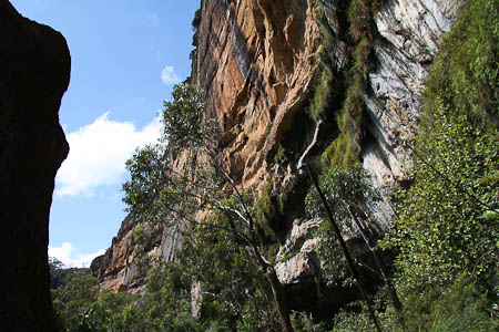
Cliffs of Colliers Causeway
Related walks
Medlow Bath to Blackheath Glen
Time: 3 hrs Distance: 7 km Fitness: E Skill: M Ascent: 370 m
An interesting walk into the Megalong Valley on old tracks.
Medlow Bath to the Colosseum
Time: 2 hrs Distance: 4 km Fitness: E Skill: EM Ascent: 170 m
Visit a delightful natural amphitheatre on old tracks.
Hanging Rock and Baltzer Lookout
Time: 4 hrs Distance: 11 km Fitness: E Skill: E Ascent: 100 m
An easy walk to the impressive Hanging Rock near Blackheath, and to Baltzer Lookout over the Grose Valley
Medlow Bath - Glen Rosa Track
Time: 3 hrs Distance: 5 km Fitness: E Skill: M Ascent: 120 m
An interesting walk exploring some rough old tracks below Medlow Bath
Medlow Bath Cliff Tracks
Time: 3 hrs Distance: 8 km Fitness: E Skill: EM Ascent: 90 m
Excellent views from the cliff top tracks of Medlow Bath below the impressive Hydro Majestic
Grand Canyon Loop
Time: 4 hrs Distance: 7 km Fitness: E Skill: EM Ascent: 240 m
An excellent walk showcasing a variety of the best scenery in the Blue Mountains.
Popes Glen and Braeside Tracks
Time: 3 hrs Distance: 9 km Fitness: E Skill: E Ascent: 170 m
A pleasant and easy walk with spectacular views
Personal reports
19/02/2010 - Colliers Causeway: Kanimbla Rd - Fort Rock - Centennial Glen - Walls Ledge - Centennial Glen - Porters Pass - Burton St (photos)