| Time: | 2 hrs |
| Distance: | 4 km |
| Fitness: | E |
| Skill: | E |
| Ascent: | 360 m |
| Maps: | LPI Mount Wilson 8930-1N 1:25000 |
| Notes: | Print-friendly notes (opens in new window) |
Introduction
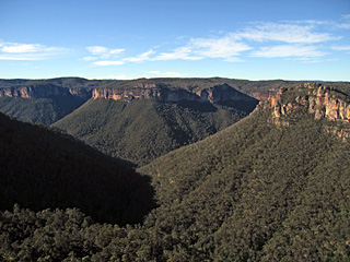
Victoria Creek and the Grose Valley from Victoria Falls Lookout
Below Victoria Falls Lookout, Victoria Creek drops steeply through a series of cascades into the Grose Valley. Victoria Falls is the largest of these, and can be reached by a relatively short, but steep, walk. The delightful Silver Cascades is only a few minutes away. The track passes along some ledges above drops, which most people will be fine with, but there is some mild exposure.
The walk is good all year round. While it is a steep climb out of the valley, the walk is reasonable in warmer months as there are opportunities for a swim.
Access
Heading west along the Great Western Highway, turn right on to Victoria Falls Rd about 500m past Browntown Oval, and 1km before the traffic lights in Mt Victoria itself. Follow the dirt road for just over 5km, ignoring minor roads off to the side, to reach a car park.
Track notes
From 09 Jul 2006, last checked 23 Oct 2016
From the car park, a signposted track leads for 150m to the lookout. Victoria Falls Lookout has a commanding view over Victoria Creek, and the Upper Grose Valley. Looking down Victoria Creek, the main head to the left is Asgard Head, in the middle are the Birrabang Walls and to the right is Burra Korain Head. The falls themselves are not visible from the lookout, although you can hear the water on a quiet day.
From the lookout, the track is obvious, as there are no real choices. The track contours down towards a small creek before cutting back under some small cliffs. For the first long zig zag, the track is well maintained with wooden steps. A little further on, the track descends through the lower cliffs at a small pass, which is quite steep.
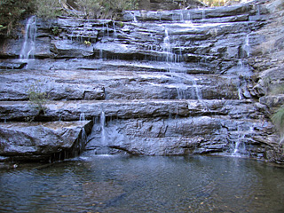
The Silver Cascades
Below this the walking is pleasant, heading steadily downhill on a trail that switches back and forth several times to finally reach Victoria Creek. The signposts here are a little confusing. The first one you meet as you hit the creek points to 'Burra Korain Flat' to the left, and 'Cascades' to the right. If you thought 'Cascades' referred to Victoria Falls themselves, you would be wrong. Heading right (upstream) for a short distance, you reach the Silver Cascades, a set of wide attractive falls that tumble down a stepped rock face into a large pool. This could be a good spot for a quick dip in summer.
Heading back to the sign and downstream, another sign post appears. A side track is marked to the top of the main falls. The falls are in two stages, and so the main part of the falls cannot be seen from the top. However, there is a large flat ledge at the top of the falls with good views down the Victoria Creek valley. Back at the junction, continue down the narrow main track towards Burra Korain Flat on the left side of the creek to the bottom of Victoria Falls. This is quite narrow, and care should be taken in the wet in a couple of places. The main falls are impressive, dropping about 20m over an overhang into a small pool.
After a break, return the way you came.
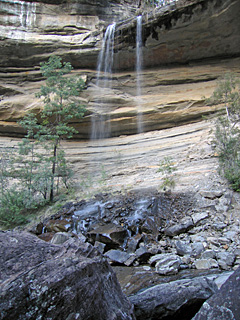
Victoria Falls
Related walks
Rigby Hill
Time: 1 hr Distance: 2 km Fitness: E Skill: E Ascent: 60 m
An easy and short walk to a fantastic lookout over the Grose Valley.
Faulconbridge Ridge to the Grose River
Time: 5 hrs Distance: 17 km Fitness: M Skill: EM Ascent: 410 m
A longish day walk to visit a great lookout and a beautiful swimming hole
Hanging Rock and Baltzer Lookout
Time: 4 hrs Distance: 11 km Fitness: E Skill: E Ascent: 100 m
An easy walk to the impressive Hanging Rock near Blackheath, and to Baltzer Lookout over the Grose Valley
Lockley Pylon
Time: 2 hrs Distance: 7 km Fitness: E Skill: E Ascent: 40 m
An easy walk to impressive views over the Grose Valley and Govetts Gorge.
Asgard Plateau
Time: 7 hrs Distance: 17 km Fitness: EM Skill: M Ascent: 350 m
Superb views of the upper Grose Valley, and a good mix of on track and easy off track walking in this less visited area
Blue Gum Forest via Evans Lookout and Perrys Lookdown
Time: 2 days Distance: 22 km Fitness: M Skill: EM Ascent: 750 m
The classic walk into the Blue Gum Forest, with camping on grassy flats under the magnificent blue gums
Mt Banks
Time: 5 hrs Distance: 15 km Fitness: EM Skill: EM Ascent: 200 m
A climb of one of the prominent peaks of the Blue Mountains, with excellent views of the Grose Valley from its slopes.
Govetts Leap and the Horse Track
Time: 7 hrs Distance: 13 km Fitness: M Skill: EM Ascent: 630 m
Visit some of the most spectacular parts of the Grose Valley on this challenging but rewarding walk.
Blue Gum Forest via Du Faur Head
Time: 6 hrs Distance: 12 km Fitness: M Skill: EM Ascent: 650 m
A challenging and scenic route in to the Blue Gum Forest
Pierces Pass
Time: 6 hrs Distance: 15 km Fitness: EM Skill: EM Ascent: 540 m
A steep descent to the Grose River through a delightful rainforest ravine, with a visit to the magnificent Blue Gum Forest.