| Time: | 2 hrs |
| Distance: | 7 km |
| Fitness: | E |
| Skill: | E |
| Ascent: | 40 m |
| Maps: | LPI Katoomba 8930-1S 1:25000 |
| Notes: | Print-friendly notes (opens in new window) |
Introduction
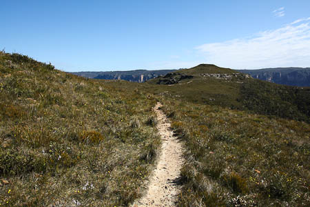
View towards Lockley Pylon from the Lockley Pylon track
Lockley Pylon is a small but distinctive peak overlooking Govetts Gorge near its junction with the Grose Valley. It was named after J.G. Lockley, Sydney Morning Herald journalist who gave a lot of support for the battle to save the Blue Gum Forest in the 1930s. The walk out to it via the Pinnacles and Mt Stead crosses a large expanse of heath, and is spectacular in spring when the wildflowers are out.
The heath is at altitude and relatively exposed, so be prepared for high winds at any time of the year.
Access
Heading west on the Great Western Highway, take the new exit at Leura and do a full lap of the roundabout at the top of the hill. Heading back down, take the left turn on to Mt Hay Rd, and reset your trip meter. Follow this round around for a few km until it becomes dirt, and at the 10km mark you should pass a couple of parking areas on the left. This is just past the marked track to Flat Top, and there is a NPWS sign at the parking areas. Park here.
Track notes
From 03 Sep 2006, last checked 22 Aug 2009
Pick up the signposted track from the end of the parking area, and follow it up the hill. Despite a bit of braiding in the track, all the separate paths join up, passing below the rock formations known as The Pinnacles. Down to your left you can see the headwaters of Fortress Creek.

Fortress Creek where it tumbles 70m into the Grose Valley
At the end of The Pinnacles, the track heads out across the heath, before dropping into a small saddle. On the other side it climbs up on to a series of rocky outcrops, and at one point a short detour to the left leads to a good lookout over Fortress Creek.
Continuing on, the track passes through upland forest across the top of Mt Stead, before emerging and winding around the northern side of a low line of hills to the foot of Lockley Pylon. To reach the summit, climb the stairs at the track junction, and continue straight up the rocky slab rather than taking a more obvious track to the left when the stairs end. They recommence across the other side of the slab, and lead all the way to the summit and the cairn. The near panoramic views from the top of the Pylon are superb. The entirety of Govetts Gorge is laid out in front of you, with the impressive outlet of Fortress Creek tumbling into the valley to your left. Further to the right are Mt Banks and the Grose Valley, with the Blue Gum Forest at the junction of Govetts Creek and the Grose River.
A well worn track to the left leads down to some even better lookouts over Fortress and Govetts Creeks.
If you want to continue a bit further, you can return to the main track and continue down the hill and across a small gully. From up on the tops on the other side of the gully there are some excellent lookouts. If you follow the track all the way to Du Faur Head, it is about 15 minutes (30 minutes return) from the Lockley Pylon turnoff.
After a break, return the way you came.
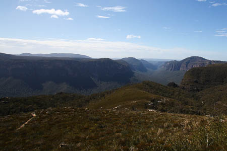
View down the Grose Valley from Lockley Pylon
Related walks
Rigby Hill
Time: 1 hr Distance: 2 km Fitness: E Skill: E Ascent: 60 m
An easy and short walk to a fantastic lookout over the Grose Valley.
Blue Gum Forest via Evans Lookout and Perrys Lookdown
Time: 2 days Distance: 22 km Fitness: M Skill: EM Ascent: 750 m
The classic walk into the Blue Gum Forest, with camping on grassy flats under the magnificent blue gums
Faulconbridge Ridge to the Grose River
Time: 5 hrs Distance: 17 km Fitness: M Skill: EM Ascent: 410 m
A longish day walk to visit a great lookout and a beautiful swimming hole
Mt Banks
Time: 5 hrs Distance: 15 km Fitness: EM Skill: EM Ascent: 200 m
A climb of one of the prominent peaks of the Blue Mountains, with excellent views of the Grose Valley from its slopes.
Hanging Rock and Baltzer Lookout
Time: 4 hrs Distance: 11 km Fitness: E Skill: E Ascent: 100 m
An easy walk to the impressive Hanging Rock near Blackheath, and to Baltzer Lookout over the Grose Valley
Victoria Falls
Time: 2 hrs Distance: 4 km Fitness: E Skill: E Ascent: 360 m
A short but steep walk to a series of pretty cascades on Victoria Creek.
Blue Gum Forest via Du Faur Head
Time: 6 hrs Distance: 12 km Fitness: M Skill: EM Ascent: 650 m
A challenging and scenic route in to the Blue Gum Forest
Asgard Plateau
Time: 7 hrs Distance: 17 km Fitness: EM Skill: M Ascent: 350 m
Superb views of the upper Grose Valley, and a good mix of on track and easy off track walking in this less visited area
Pierces Pass
Time: 6 hrs Distance: 15 km Fitness: EM Skill: EM Ascent: 540 m
A steep descent to the Grose River through a delightful rainforest ravine, with a visit to the magnificent Blue Gum Forest.
Personal reports
Links
 Bushwalks in the Sydney Region Vol 1 (Edition 4), S Lord and G Daniel
An excellent resource for walkers, with a variety of walks within easy reach of Sydney
 Katoomba and Leura - Allan Wells
Good description of a number of walks in the Katoomba/Leura region
Lockley Pylon - Wild Walks
Track notes for Lockley Pylon walk