| Time: | 6 hrs |
| Distance: | 15 km |
| Fitness: | EM |
| Skill: | EM |
| Ascent: | 540 m |
| Maps: | LPI Mount Wilson 8930-1N 1:25000 |
| Notes: | Print-friendly notes (opens in new window) |
Introduction
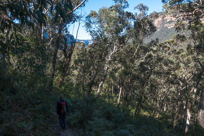
Descending the Pierces Pass Track into the Grose Valley
Pierces Pass is the most commonly used route into the Upper Grose Valley from the north side of the valley. It was probably constructed in the early 1930s by Bert Pierce and Clarrie Hungerford to access the Blue Gum Forest for cattle grazing, though the track may be much older.
The walk from Pierces Pass to the Blue Gum Forest is probably best in the cooler months, due to the steep climb out. However, there are a number of lovely swimming holes on the Grose River that would be good for a dip in summer.
The track both from Pierces Pass to the Grose river and from the Grose River to Blue Gum forest in some places passes along some narrow ledges above significant drops. Most people will have no problem with this, but there is a small amount of mild exposure.
Access
The walk starts at the lower picnic area at Pierces Pass, approximately 2 hours drive from Sydney.
If coming from Sydney, take Bells Line of Road (B59) past Mt Tomah. About 9km past Mt Tomah, note the signposted turnoff to Mt Banks, and 1.6km past this, take the signposted turnoff to the left to Pierces Pass.
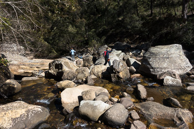
Crossing the Grose River on boulders at the bottom of the pass
The road to the bottom is 850m long and is unsealed. It is normally fine for 2wd vehicles. Ignore the turnoff to the top car park just after you turn off Bells Line of Road, and proceed to the bottom car park to park.
Track notes
From 27 Aug 2017, last checked 27 Aug 2017
Take the track to the north-west signposted to the Grose River. This heads down the slope and zig zags into a small gully. After a short while the track swings to the left and descends into Pierces Creek, which is a beautiful rainforest ravine. There is a small track off to the right that descends down to the creek and some cascades at one point. Eventually the ravine opens out and the track swing to the left and contours gently down the slope with some good views of the cliffs and the valley to the other side.
As the track approaches the next major gully, it starts to switch back and forth, and then descends steeply down a spur to the Grose River.
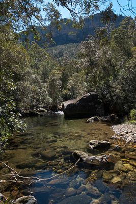
Cliffs above the Grose River on the way to the Blue Gum Forest
Cross the river on boulders, and pick up the track on the other side which is at river level. Turn left, and head downstream. The track is generally quite narrow, but fairly easy to follow. It is mostly flat but undulates up and over a number of spurs, and drops into a number of small creeks. There are a number of stands of Blue Gums on both sides of the river. Prior to the Blue Gum Forest, the largest of these is at Little Blue Gum. This is a small grassy camping area overlooked by the massive south western face of Mt Banks, some of the highest cliffs in the Blue Mountains.
Beyond Little Blue Gum, the track climbs up and over a another spur and then descends to the Blue Gum Forest. The Blue Gums here are especially impressive, and get larger as you approach the middle of the forest.
After about 10 minutes you reach the sign board and a 4 way track junction.
If you turn left here, a short walk takes you down to Govetts Creek, where there are some nice spots to sit and have lunch. Alternatively, you can walk downstream a short way to a crossing on a large log and from there a short walk to the junction with the Grose River, which is also pleasant. After a break, return to the four way junction, and retrace your steps back to the car.
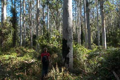
Blue Gum Forest
Related walks
Rigby Hill
Time: 1 hr Distance: 2 km Fitness: E Skill: E Ascent: 60 m
An easy and short walk to a fantastic lookout over the Grose Valley.
Faulconbridge Ridge to the Grose River
Time: 5 hrs Distance: 17 km Fitness: M Skill: EM Ascent: 410 m
A longish day walk to visit a great lookout and a beautiful swimming hole
Lockley Pylon
Time: 2 hrs Distance: 7 km Fitness: E Skill: E Ascent: 40 m
An easy walk to impressive views over the Grose Valley and Govetts Gorge.
Victoria Falls
Time: 2 hrs Distance: 4 km Fitness: E Skill: E Ascent: 360 m
A short but steep walk to a series of pretty cascades on Victoria Creek.
Asgard Plateau
Time: 7 hrs Distance: 17 km Fitness: EM Skill: M Ascent: 350 m
Superb views of the upper Grose Valley, and a good mix of on track and easy off track walking in this less visited area
Blue Gum Forest via Evans Lookout and Perrys Lookdown
Time: 2 days Distance: 22 km Fitness: M Skill: EM Ascent: 750 m
The classic walk into the Blue Gum Forest, with camping on grassy flats under the magnificent blue gums
Blue Gum Forest via Du Faur Head
Time: 6 hrs Distance: 12 km Fitness: M Skill: EM Ascent: 650 m
A challenging and scenic route in to the Blue Gum Forest
Popes Glen and Braeside Tracks
Time: 3 hrs Distance: 9 km Fitness: E Skill: E Ascent: 170 m
A pleasant and easy walk with spectacular views