| Time: | 4 hrs |
| Distance: | 11 km |
| Fitness: | EM |
| Skill: | EM |
| Ascent: | 200 m |
| Maps: | LPI Springwood 9030-4S 1:25000 |
| Sketch maps: | Sketch map 1 PDF |
| Notes: | Print-friendly notes (opens in new window) |
Introduction
Martins Falls
The walk down Magdala Creek to Martin's Lookout, returning via Glenbrook Creek is a pleasant day walk along a couple of nice creeks, with some great views across the Lower Blue Mountains from the lookout. While it can be done at any time of year, it is probably best done in the warmer months there are numerous opportunities for swimming, and much of the walk is under the canopy. Avoid walking immediately after heavy rain as there are numerous creek crossing - you will get wet feet and sections may be impassable.
Access
The walk starts and finishes at Springwood Station.
If you are coming by car, it is best to park on Springwood Av, or in the car park behind the plaza between Westpac and Priceline.
Track notes
From 27 May 2000, last checked 29 Aug 2020
From Springwood Station, turn left and walk up the road for 200 m to the pedestrian crossing opposite the commuter car park. Cross the road, walk through the plaza between Westpac and Priceline, and through the car park to Springwood Ave. Cross Springwood Ave and walk down an access road immediately opposite.
The Magdala Creek Track starts at the bottom of this access road.
Walk down the creek for about 500m to where a track leads up to the right to Picnic Point. If you had a car, you could also choose to start here.
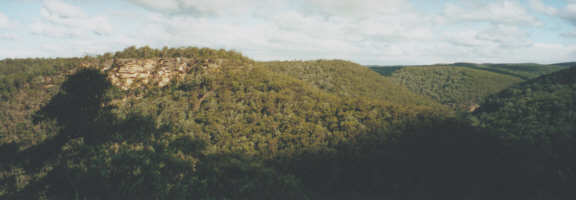
Martins Lookout has panoramic views across the lower Blue Mountains
Continue on for another 200 m to a signposted junction to Lawsons Lookout. The main track is indistinct at this junction, as it goes directly down the creek itself, on the eastern side, so keep a close eye out. Otherwise you'll find yourself heading up to Lawsons Lookout.
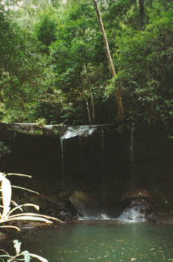
The track steadily drops following the creek. There are a number of creek crossings, which you should be able to keep dry feet for at normal water levels. Presently you reach a short detour to Magdala Falls, hidden behind the trees, and the Blue Pool, so called because of the colour imparted by the clay particles suspended in the water. Shortly after that is the picturesque Martins Falls, which drop several metres over a ledge into a small pond.
Soon you come to the Perch Ponds - though you will be doing well to spot perch, or any other fish for that matter. Here the trail splits - left for the Martins Lookout loop, right to start the trip back. Take the left branch.
The path runs alongside Glenbrook Creek, and there are lots of potential swimming holes and a couple of sandy beaches to stop at. After about 500m the track splits again, and you can decide whether to take the Short Track, to the left, or the Long Track up to the lookout. Whatever your choice you've got 170m vertical to cover in just a few hundred metres.

'The Swimming Hole' - a nice spot for a swim in summer
The view from the top is great. Directly across Glenbrook Creek you can see a white cross on the cliffs on the other side. The cliff is the Lost World Lookout, which can be reached by walking down and then up the other side, and the cross is a memorial to Rev. Br. G.E. Rayner, who used to take students bushwalking in this area.
Returning to the Perch Ponds, head up the Victory Track following Glenbrook Creek. This is easy walking, passing plenty of nice potential swimming pools. After a couple of kilometres you reach a large one, locally and imaginatively called "The Swimming Hole". It would be a good stop for a break in the middle of summer, but not a cold and windy winter's day. Following the track further upstream you reach the junction with the Wiggins Track going off to the right. This is the quickest walk out, but continuing a bit further again you get to the Sassafras Gully Track This is a bit of a climb, although not much compared to Martins Lookout.
This brings you back to the road in a little over 1 km. Follow the road (Sassafras Gully Rd) to the end and turn left into Valley Rd and immediately right into Short St. This will take you back to the railway line. Turn right and follow the railway line for 600m to the station.
An alternative route out if you're keen for more walking is to keep following the Victory Track past Sassafras Gully all the way up to Faulconbridge, and then walk back along the road for 3 km. This adds about 4 km total to the route above.
Related walks
Faulconbridge Ridge to the Grose River
Time: 5 hrs Distance: 17 km Fitness: M Skill: EM Ascent: 410 m
A longish day walk to visit a great lookout and a beautiful swimming hole
Glenbrook to Springwood
Time: 7 hrs Distance: 21 km Fitness: M Skill: EM Ascent: 530 m
An excellent walk in the lower Blue Mountains following both ridges and creeks.
Kanuka Brook
Time: 5 hrs Distance: 11 km Fitness: EM Skill: M Ascent: 170 m
An excellent day walk in the lower Blue Mountains following both ridges and creeks.
Personal reports
27/05/2000 - Magdala Creek: Springwood - Magdala Ck - Sassafras Ck - Wiggins Track (photos)
Links
 Bushwalking - Cycling - Jogging in the Lower Blue Mountains, Robert Sloss
A reasonably comprehensive overview of trails in the area of the lower Blue Mountains south of the Great Western Highway.