Overview
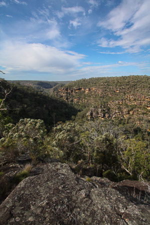
Looking out over the rugged cliffs lining Big Crater Creek, in the lower part of the Blue Labyrinth
The Blue Labyrinth is the name given to the area of the Blue Mountains east of the Kings Tableland and south of the Great Western Highway. Lake Burragorang and the Nepean River form natural boundaries to the south and east. It is rough and rugged sandstone country, dissected by steep gorges feeding into the two major creek systems of Glenbrook Creek and Erskine Creek.
It was extensively explored in the 1930s, 40s and 50s by the Hall brothers and the Warrigal Club, but has fallen out of favour in more recent years.
Access
The northern edge of the area abuts the Blue Mountains towns from Wentworth Falls down to Glenbrook, and roads and tracks leave from almost all of the towns.
At Wentworth Falls, Kings Tableland Rd leads south to McMahons Lookout, and various fire trails leave from this road heading east. Further east at Woodford, Murphys Trail and the Oaks Fire Trail Trail lead south into the heart of the labyrinth. The national park entrance at Glenbrook also allows access via a number of fire trails. The eastern end of the Oaks Fire Trail, Red Hands Fire Trail and the Nepean Lookout Fire Trail can all be driven to parts of the Blue Labyrinth.
Activities
Bushwalking
There are many short tracks on the northern edge of the Blue Labyrinth, particularly around the towns Springwood and Faulconbridge. These include the Sassafras Track, Victory Track, Wiggins Track, Magdala Creek Track and Martins Lookout Trail, which can be linked to form longer walks. Further up the mountains, at Hazelbrook, the waterfalls of Adelina Falls, Junction Falls, Federal Falls, Victor Falls and Terrace Falls can be visited on short walks, or linked for one longer walk.
Down at Glenbrook, there are short walks to the Blue Pool, Jellybean Pool, Glenbrook Gorge, the Duck Hole and Red Hands Cave.
Longer walks typically involve some off track component, but one long walk on tracks (of sorts) is from Glenbrook to Springwood or Faulconbridge, via St Helena Crater. This can be done over one or two days.
Other walks that involve some rough track or off track include Kanuka Brook and Erskine Creek.
Canyoning
Mountain Biking
Walks
Erskine Creek
Time: 6 hrs Distance: 13km Fitness: EM Skill: M Ascent: 200m
An excellent summer day walk in the Lower Blue Mountains with beautiful swimming holes
Magdala Creek
Time: 4 hrs Distance: 11km Fitness: EM Skill: EM Ascent: 200m
A pleasant summer walk along shady paths, with a short climb to a good lookout.
Glenbrook to Springwood
Time: 7 hrs Distance: 21km Fitness: M Skill: EM Ascent: 530m
An excellent walk in the lower Blue Mountains following both ridges and creeks.
Kanuka Brook
Time: 5 hrs Distance: 11km Fitness: EM Skill: M Ascent: 170m
An excellent day walk in the lower Blue Mountains following both ridges and creeks.