| Time: | 5 hrs |
| Distance: | 15 km |
| Fitness: | EM |
| Skill: | E |
| Ascent: | 350 m |
| Maps: | LPI Kurrajong 9030-4N 1:25000 |
| LPI Springwood 9030-4S 1:25000 | |
| Notes: | Print-friendly notes (opens in new window) |
Introduction

Early morning light in Blue Gum Swamp Creek
Grose Head South is an imposing peak on the south side of the Grose River, not far from where it drains into the Nepean River to form the Hawkesbury River. A good way to reach it is from Winmalee, following Blue Gum Swamp Creek with its gorgeous stands of Blue Gums. There are spectacular lookouts on the ridge overlooking Springwood Creek and the Grose Valley.
Access
The walk starts at the end of White Cross Rd in Winmalee.
Driving west along the Great Western Highway (A32), and after passing through Valley Heights, turn left on Macquarie Rd, signposted to Winmalee and Richmond. Turn right at the roundabout after 750m. Continue through the next roundabout and follow Hawkesbury Rd for 5.0km. Turn left at the traffic lights on to White Cross Rd and follow it for 450m to the end.
Track notes

Near Grose Mountain Lookout
From 30 May 2020, last checked 30 May 2020
The walk is relatively straightforward, and fairly well-signposted. The main tracks are all shown on the topographic map.
Pass through the gate at the end of the road, and after 200m, turn left at an intersection of fire trails on to the Blue Gum Swamp Track. This goes steeply down the hill. At the bottom of the hill at another junction, keep right. The track follows Blue Gum Swamp Creek for the next the 3km, crossing the main creek once, and passing through a number of beautiful stands of Deane's Blue Gums (Eucalyptus deanei).
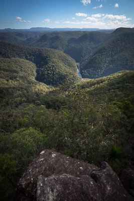
Views of the Grose River from just below the summit of Grose Head South
At the next major intersection, signposted, turn left and head up the steep hill on the Bees Nest Fire Trail. At the top of the 150m climb, turn right on Springwood Ridge Trail, and follow this for about 1km to Grose Mountain Lookout, which has superb views of Grose Mountain and the lower Grose Valley. The lookout is in fact the first of a series of three lookouts in quick succession, all of which have good, but similar, views.
Continue along a foot track past the other two lookouts, and then climb steeply up a rocky eroded track that leads after about 20 minutes to the trig station on Grose Head South. The views from the summit are limited, but there are filtered views of the Grose both from near the summit and from the track on the way up.

Descending off Grose Head South
Return to the lookouts, and then retrace your route back down the steep hill to Blue Gum Swamp Creek. Turn left and follow the Shaws Ridge Trail through one of the most impressive stands of Blue Gums, before climbing a steep hill on to the ridge.
Continue along Shaws Ridge Trail for about 3.5km back to the first intersection, from where it is a short walk back to your car.
It is also possible to return via the Springwood Ridge Trail, which is a couple of kilometres longer, or the way you came, along Blue Gum Swamp Creek.
Related walks
Faulconbridge Ridge to the Grose River
Time: 5 hrs Distance: 17 km Fitness: M Skill: EM Ascent: 410 m
A longish day walk to visit a great lookout and a beautiful swimming hole