Overview
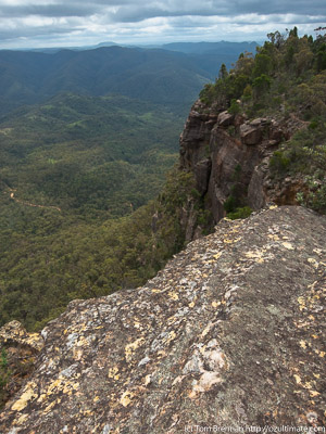
The ridge to Bonnum Pic, Nattai NP
Nattai National Park makes up much of the southern section of the Greater Blue Mountains World Heritage Area, and takes in the catchments of the Nattai and Wollondilly Rivers. Like the other parks in the WHA, it is characterised by massive sandstone cliffs and deep gorges. The park itself is nearly 50,000 ha, and lies 80 km south west from Sydney. It is relatively undeveloped, and much of the park is wilderness. The park abuts Lake Burragorang and the Warragamba Catchment, and there is no access through much of this area.
Access
The best access for the northern part of the park is through Thirlmere Lakes NP, via the Middleton Memorial Drive. The central part can be reached via Wattle Ridge Road and Nattai Rd, which leaves from the town of Hill Top. Futher south, Wombeyan Caves Rd and Wanganderry Rd provide access to the Wanganderry Tablelands, Burnt Flat Creek and the Bonnum Pic walk.
The western side of the park can be accessed from Yerranderie, via a long rough drive on the Colong to Oberon Stock Route.
There is very limited access by public transport. Trains run to Picton and Bowral, and occasional buses from those stations to Couridjah and Hill Top. Check timetables. From Couridjah it is about a 5km walk through Thirlmere Lakes NP to the Nattai NP boundary. From Hill Top it is still about 10km to the park gate on Wattle Ridge.
Activities
Bushwalking
There are few formed tracks in Nattai NP, as much of the park is wilderness, and some of it in the Warragamba Catchment. There are a number of tracks in the Wattle Ridge area, the most well known ones being Starlights Track to the Nattai River, as well as the spectacular Ahearn Lookout.
To the north is the Couridjah Corridor walk, from Thirlmere Lakes NP along Blue Gum Creek. There is also the well-known longer walk from Mittagong to Katoomba, which passes along the Nattai River before climbing over Beloon Pass into the Wollondilly Valley and continuing into Yerranderie and the Blue Mountains NP.
Bonnum Pic is another excellent walk, though it is only partly on track as part of the walk is in the Nattai Wilderness.
There are plenty of off-track options for walkers, from the Wanganderry Tablelands to the Allum River Canyon, though most sections near the water catchment are out of bounds for bushwalking.
Walks
Bonnum Pic
Time: 7 hrs Distance: 16km Fitness: EM Skill: M Ascent: 80m
Spectacular views and interesting rock formations on this walk to a knife-edge ridge in the Wollondilly Valley
Starlights Track
Time: 5 hrs Distance: 13km Fitness: EM Skill: EM Ascent: 440m
Easy walk down to beautiful grassy campsites on the Nattai River
Ahearn Lookout
Time: 4 hrs Distance: 12km Fitness: E Skill: EM Ascent: 80m
A relatively easy walk to a spectacular lookout
Couridjah Corridor
Time: 4 hrs Distance: 17km Fitness: EM Skill: E Ascent: 100m
Easy fire trail walking to the Little River, through one of the most impressive stands of Blue Gums around Sydney
Slott Way
Time: 5 hrs Distance: 11km Fitness: EM Skill: EM Ascent: 450m
A short steep route to the middle Nattai River, with views on the way in
Russells Needle
Time: 9 hrs Distance: 18km Fitness: H Skill: MH Ascent: 700m
Challenging walk with some scrambling to reach the top of an impressive knife-edge ridge
Troys Creek Track
Time: 7 hrs Distance: 20km Fitness: M Skill: EM Ascent: 440m
A longish but relatively easy day to grassy flats on the Nattai River
Box Vale Tramway
Time: 5 hrs Distance: 11km Fitness: EM Skill: M Ascent: 180m
A challenging walk involving an historic railway line, rugged river walking and an impressive waterfall