| Time: | 4 hrs |
| Distance: | 17 km |
| Fitness: | EM |
| Skill: | E |
| Ascent: | 100 m |
| Maps: | LPI Nattai 8929-1S 1:25000 |
| LPI Picton 9029-4S 1:25000 | |
| Notes: | Print-friendly notes (opens in new window) |
Introduction
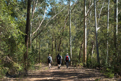
Fire trail along Blue Gum Creek
In the 1920s, one of the most magnificent stands of Blue Gums in the Sydney area grew along the Couridjah Corridor, along Blue Gum Creek from Thirlmere Lakes to the Little River. These were unfortunately logged, but have grown back in the nearly 100 years since, and rival the Blue Gum Forest at Blackheath.
This easy walk follows Blue Gum Creek down to the Little River, passing a number of stands of these beautiful trees. Some of the best stands are in the first few kilometres of the trail, so if you are not up for a longer walk, even a short stroll will allow you to see some of the trees.
Access
The walk starts at the locked gate at on WE Middleton Drive, near Thirlmere Lakes
Coming from Sydney, head south on the Hume Highway (M31), take the Picton Road exit and turn right on to Picton Rd (B88). Follow this to the Old Hume Hwy in Picton, turn left, and then right on to Thirlmere Way after 2km. Follow this for 4.7km to Thirlmere, and turn right at the roundabout, and then left after crossing the railway line. Follow this for 3.9km and turn right on to WE Middeton Memorial Drive, which is hard to spot.
This immediately becomes dirt. Follow it for 1.1km to a T-intersection, and turn left. The Lake Couridjah picnic area should be on your right after 100m.

Little River junction
Reset your speedo here, and continue following the road past the picnic area. Pass a fire trail on the right after 2.9km, and keep straight ahead at 3.2km, where a fire trail veers off to the right into private property. Park at a wide area of road at 4.7km. While you can drive a little further, there are no parking spots and it is difficult to turn around.
Track notes
From 11 Sep 2016, last checked 11 Sep 2016
Walk down the road, keeping left at a fork where there is a locked gate on the right hand branch. After 100m there is a locked gate on this branch of the road. Pass through the gate and follow the fire trail down to a creek crossing at a badly damaged concrete ford. This section of trail boasts some of the most impressive stands of Blue Gums on the walk, and is well worth the visit even if you don't go all the way to Little River.
The fire trail is mostly flat from here to the junction of Blue Gum Creek with Couridjah Creek, about 6km. There are then a few ups and downs as the trail winds in and out of several gullies, before finishing with another kilometre of flat walking to Little River. This is a lovely spot for a break, with large sandstone boulders dotting the river.
After a break, return the way you came.
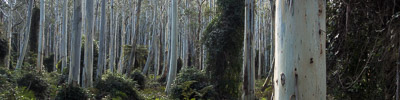
Blue Gums in the Couridjah Corridor
Related walks
Starlights Track
Time: 5 hrs Distance: 13 km Fitness: EM Skill: EM Ascent: 440 m
Easy walk down to beautiful grassy campsites on the Nattai River
Ahearn Lookout
Time: 4 hrs Distance: 12 km Fitness: E Skill: EM Ascent: 80 m
A relatively easy walk to a spectacular lookout
Slott Way
Time: 5 hrs Distance: 11 km Fitness: EM Skill: EM Ascent: 450 m
A short steep route to the middle Nattai River, with views on the way in
Russells Needle
Time: 9 hrs Distance: 18 km Fitness: H Skill: MH Ascent: 700 m
Challenging walk with some scrambling to reach the top of an impressive knife-edge ridge
Troys Creek Track
Time: 7 hrs Distance: 20 km Fitness: M Skill: EM Ascent: 440 m
A longish but relatively easy day to grassy flats on the Nattai River