| Time: | 5 hrs |
| Distance: | 13 km |
| Fitness: | EM |
| Skill: | EM |
| Ascent: | 440 m |
| Maps: | LPI Hilltop 8929-2N 1:25000 |
| Notes: | Print-friendly notes (opens in new window) |
Introduction
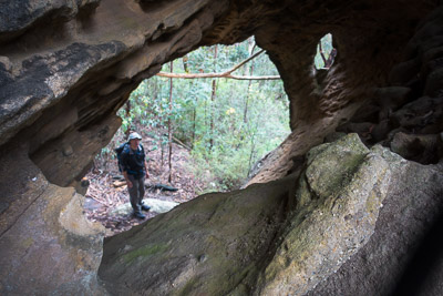
Hollow boulder on the track
Starlights Track provides the easiest access to the middle Nattai River. Apart from one short steep section near the river, it is a gentle gradient down to a beautiful grassy campsite on the river opposite Mcarthurs Flat.
While the walk as described is a day walk, good camping means that it is an option for an easy overnight walk, with extra time to explore.
Access
The walk starts from the car park at the end of Wattle Ridge Road, in Hill Top.
Coming from Sydney, take the Hume Highway (M31) south, and take Exit 10 (Church Ave) signposted to Colo Vale, Hill Top and Yerrinbool. Turn right at the roundabout to cross the freeway, and then right again on to Wilson Dr after 1.6km, just before crossing the abandoned railway. After 5.2km turn left on to Chalker Parade, and then follow the road around to the right after it crosses the old railway line, and becomes West Parade. This takes you into the village of Hill Top, which includes the Hilltop Village Bakery and Cafe, opening early on the weekends.
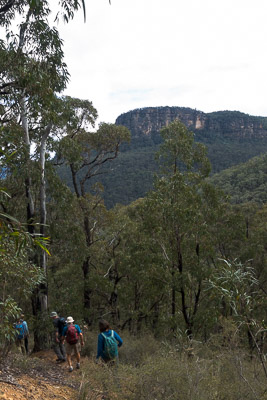
Heading down the steep ridge into the valley
Continue along West Parade. As the road veers north-west, it becomes Wattle Ridge Road. Not far out of the village the bitumen ends, and it becomes a generally good quality dirt road, 2wd accessible under normal conditions. Follow this to the car park at a locked gate, opposite the private property of Wattle Ridge. There is parking for around 8-10 cars, and an information board at the car park.
The car park can be busy on weekends so consider car pooling from Hill Top.
Track notes
From 10 Sep 2016, last checked 10 Sep 2016
Pass through the locked gate to the west, and follow the fire trail around the perimeter of the Wattle Ridge property for 1.7km (25 min) to an intersection with a less distinct fire trail, and a signboard. Take the left branch on to the less distinct track, signposted to Starlights Trail. This heads over a small rise. After 400m (5 min), take a right turn on to a foot track at 618011 (Hilltop), marked with S.T. painted on the ground on a rock.
This track undulates for 250m to a clearing. Take the track heading SW into the top of the gully.
This is Starlights Track.
It is about 4km (1.5 hr) from here to the Nattai River, and is gently graded and fairly easy to follow. There is an interesting massive hollow boulder on the right of the track after about 800m (10 minutes). Further down the track descends to follow the creek for a distance, before contouring for a bit as the creek begins to open out, and the massive sandstone cliffs of the Nattai Valley come into view. Note a large, usually dry waterfall in the main creek below.
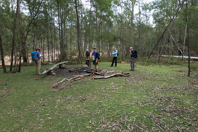
Great grassy camping flats at the river
The track soon begins to descend again, winding in and out of a number of small dry gullies. It then steeply descends via a series of switchbacks to the main creek. Cross the creek, and pick up the track on the other side, that leads to a beautiful grassy clearing on the banks of the Nattai River, opposite Mcarthurs Flat. There are a number of good campsites here.
You can continue along the track to the north west to Emmetts Flat, where there are some interesting ruins, and alternative campsites. You could also explore across the river to Mcarthurs Flat.
After a break, return the way you came.
One option for making a longer day is to visit Ahearn Lookout. This can be done via the usual track, or for experienced walkers, a circuit can be made by leaving Starlights Track at around 597018, near the dry waterfall, and heading up the steep slope to the south. This involves rock scrambling and mild exposure to attain the top of the ridge. There is no track, though you may find the occasional cairn.
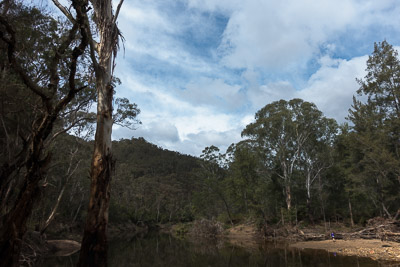
Nattai River
Related walks
Bonnum Pic
Time: 7 hrs Distance: 16 km Fitness: EM Skill: M Ascent: 80 m
Spectacular views and interesting rock formations on this walk to a knife-edge ridge in the Wollondilly Valley
Ahearn Lookout
Time: 4 hrs Distance: 12 km Fitness: E Skill: EM Ascent: 80 m
A relatively easy walk to a spectacular lookout
Couridjah Corridor
Time: 4 hrs Distance: 17 km Fitness: EM Skill: E Ascent: 100 m
Easy fire trail walking to the Little River, through one of the most impressive stands of Blue Gums around Sydney
Slott Way
Time: 5 hrs Distance: 11 km Fitness: EM Skill: EM Ascent: 450 m
A short steep route to the middle Nattai River, with views on the way in
Russells Needle
Time: 9 hrs Distance: 18 km Fitness: H Skill: MH Ascent: 700 m
Challenging walk with some scrambling to reach the top of an impressive knife-edge ridge
Troys Creek Track
Time: 7 hrs Distance: 20 km Fitness: M Skill: EM Ascent: 440 m
A longish but relatively easy day to grassy flats on the Nattai River
Personal reports
07-08/04/2018 - Nattai River: Wattle Ridge - Ahearn Lookout - Slott Way - Nattai River - (near) Emmetts Flat (C) - Starlights Track - Chasm Lookout(?) - Wattle Ridge [SBW] (photos)