| Time: | 9 hrs |
| Distance: | 18 km |
| Fitness: | H |
| Skill: | MH |
| Ascent: | 700 m |
| Maps: | LPI Hilltop 8929-2N 1:25000 |
| Notes: | Print-friendly notes (opens in new window) |
Introduction
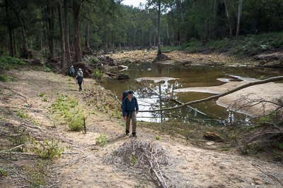
Walking up the Nattai River
Russells Needle is a rocky sandstone spine, separated by a deep saddle from the main cliff line, which sticks out dramatically into the Nattai Valley. The summit ridge offers tremendous views. Attaining the summit, or at least the summit plateau, is achievable for experienced bushwalkers with a head for heights. Some route finding and easy rock scrambling is required. There is no formal track once you reach the Nattai River.
Russells Needle can be reached as a long day trip from Wattle Ridge Road, via Slott Way, or as a more relaxed overnight trip. If doing it as an overnight trip, an alternative option would be to return via Starlights Track.
Access
The walk starts from the car park at the end of Wattle Ridge Road, in Hill Top.
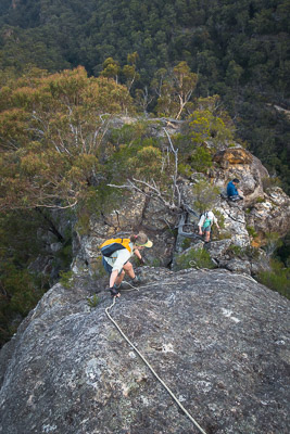
Scramble up on to the summit ridge of Russells Needle
Coming from Sydney, take the Hume Highway (M31) south, and take Exit 10 (Church Ave) signposted to Colo Vale, Hill Top and Yerrinbool. Turn right at the roundabout to cross the freeway, and then right again on to Wilson Dr after 1.6km, just before crossing the abandoned railway. After 5.2km turn left on to Chalker Parade, and then follow the road around to the right after it crosses the old railway line, and becomes West Parade. This takes you into the village of Hill Top, which includes the Hilltop Village Bakery and Cafe, opening early on the weekends.
Continue along West Parade. As the road veers north-west, it becomes Wattle Ridge Road. Not far out of the village the bitumen ends, and it becomes a generally good quality dirt road, 2wd accessible under normal conditions. Follow this to the car park at a locked gate, opposite the private property of Wattle Ridge. There is parking for around 8-10 cars, and an information board at the car park.
The car park can be busy on weekends so consider car pooling from Hill Top.
Track notes
From 13 May 2017, last checked 13 May 2017
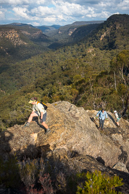
Climbing the summit ridge
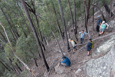
Pass through the locked gate to the west, and follow the fire trail around the perimeter of the Wattle Ridge property for 1.7km (25 min) to an intersection with a less distinct fire trail, and a signboard. Take the left branch on to the less distinct track, signposted to Starlights Trail. This heads over a small rise. After 400m (5 min), note a turnoff to the right at 618011 (Hilltop) marked with S.T. painted on the ground on a rock, and continue on the fire trail for another 130m keeping a close eye out for another fainter (unmarked) track heading off to the right. If the fire trail is heading SE, you have probably missed the turnoff and gone too far.
Turn on to this track, which heads up an almost over the top of Point Hill, from where there are glimpses of views down to the valley. It then descents gently for the next 800m (15 min) into a small gully, to a track junction at 609009. The right hand branch, climbing up on to the ridge, leads to Ahearn Lookout. Take the left hand branch, Slott Way, which leads down the south (left hand) side of the gully.
Near the summit of the Needle
The track is relatively well-marked with tape, and blue metal markers. The track quickly cuts across to the north the gully and then sidles above the creek on the right-hand side for the next 800m. A good lookout on a protruding (and airy) rock ledge is reached with views of the valley, though not of Russells Needle.
From here, the track heads steeply down to the left, starting with a slightly awkward climb down. The track follows the minor ridge briefly before cutting steeply right under a small cliff line. Keep a close eye on the markers. After a further steep descent, the track gradient eases off as the route follows a spur generally west. The Nattai River is reached at 593002
Cross the Nattai and follow it upstream (south) on the true left. The Nattai and Rocky Waterholes Creek junction is shortly after you reach the Nattai, and is vague, so being on the true left ensures you are following the Nattai!
The banks of the Nattai can be scrubby at times, but at the time of writing the going is fairly good due to significant floods in early 2016.
Using a handline to help descend the summit
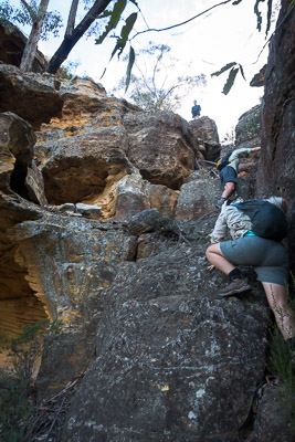
Follow the Nattai south for 2km until you reach the foot of the ridge which rises to the south up to Russells Needle. Climb the ridge south up to the cliff line, through prickly vegetation. Sidle to the east along the cliff line on somewhat loose scree slopes for around 400m until you can see a spot to scramble up to the top of the ridge. One spot is around 599976 but there are probably others. The summit ridge is a narrow rocky causeway with impressive views both east and west.
Follow the summit ridge north for about 200m to the summit. There is some easy scrambling in various spots, nothing particularly exposed until you reach the final climb. At this point you can either scramble easily, but with some possible exposure, onto the summit plateau. Alternatively, drop down to the eastern side of the ridge and walk up an unexposed footpad to the summit plateau, which has superb, near 360 degree views.
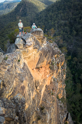
The true summit is a large boulder perched on a block with an ominous looking crack in it, reached by a narrow vertiginous causeway. Approach at your own risk!
After taking in the views return the way you came.
Steep descent back to the Nattai
Related walks
Starlights Track
Time: 5 hrs Distance: 13 km Fitness: EM Skill: EM Ascent: 440 m
Easy walk down to beautiful grassy campsites on the Nattai River
Couridjah Corridor
Time: 4 hrs Distance: 17 km Fitness: EM Skill: E Ascent: 100 m
Easy fire trail walking to the Little River, through one of the most impressive stands of Blue Gums around Sydney
Ahearn Lookout
Time: 4 hrs Distance: 12 km Fitness: E Skill: EM Ascent: 80 m
A relatively easy walk to a spectacular lookout
Slott Way
Time: 5 hrs Distance: 11 km Fitness: EM Skill: EM Ascent: 450 m
A short steep route to the middle Nattai River, with views on the way in
Troys Creek Track
Time: 7 hrs Distance: 20 km Fitness: M Skill: EM Ascent: 440 m
A longish but relatively easy day to grassy flats on the Nattai River
Box Vale Tramway
Time: 5 hrs Distance: 11 km Fitness: EM Skill: M Ascent: 180 m
A challenging walk involving an historic railway line, rugged river walking and an impressive waterfall
Personal reports
21-22/09/2019 - Russells Needle: Wattle Ridge - Ahearn Lookout - Slott Way - Nattai River - Russells Needle - Nattai River (C) - Rocky Waterholes Creek - The Chasm - unnamed creek - Fingers Lokoout - Wattle Ridge [SBW] (photos)