| Time: | 5 hrs |
| Distance: | 11 km |
| Fitness: | EM |
| Skill: | M |
| Ascent: | 180 m |
| Maps: | LPI Mittagong 8929-2S 1:25000 |
| Notes: | Print-friendly notes (opens in new window) |
Introduction
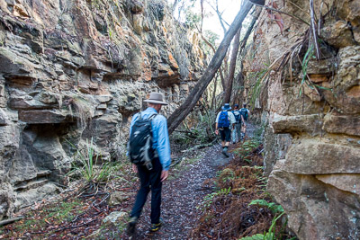
Casuarina Cutting
The Box Vale Tramway was a branch railway completed in 1888 to haul coal from a mine on the Nattai River. The mine only operated consistently for less than 2 years, and the railway was dismantled in 1896. The route was restored as a walking track around 1985.
This walk follows the line of the old railway and incline tramway to the Nattai River, before following a rugged track up the river to Forty Foot Falls. From there it is an easy walk on well formed tracks back to the start. The track is reasonably well signposted with wooden post markers, though there are a lot of fire trails in the area that can cause confusion.
For the less adventurous, it is also possible to do out and back visits to the Nattai Gorge lookout and Forty Foot Falls, which would cut out the descent of the incline and the Nattai River walk.
Access
The walk starts and finishes at the Box Vale Tramway car park.
Heading south from Sydney on the Hume Motorway (M31), take the Old Hume Highway (B73) towards Mittagong. After 6.2km, veer right off the B73, staying on the Old Hume Highway in the middle of Mittagong. Continue along the Old Hume Highway for 3.5km, and turn right on to Boxvale Rd. Turn left into the reserve after 150m, and then pull into the car park on the left after another 200m.
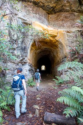
The entrance to the tunnel
There is parking for a reasonable number of cars, and an information board at the car park.
Track notes
From 24 Mar 2018, last checked 24 Mar 2018
Locate the signboard on the southern side of the car park, and follow the track that heads gently down and across Nattai Creek. From the track on the other side of the creek, there are glimpses of Welby Reservoir off to the left, and some faint tracks head in that direction if you want to get a better look. Otherwise continue along the track as it begins to follow the line of the old tramway.
The track crosses over a number of fire trails, and you should keep straight ahead at each of these. While some of the sections of the tramway route were built up on an embankment, after the third fire trail crossing you pass into the impressive Casuarina Cutting. There are two more cuttings, Boulder Cutting and Fern Cutting, before the 84m tunnel cut through a sandstone rib. About 300m past here, the top of the Box Vale Incline, where coal was hauled up from the mine, is reached.
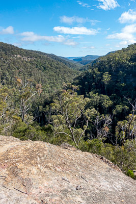
Nattai Gorge Lookout
Before descending the incline, take the signposted track to the right to the lookout, advertised as 600m, but in fact about half that. This has good views over the upper Nattai River, though the views are better from areas beyond the fence.
Return to the junction and head down the incline. This is very steep, and loose in places, and great care needs to be taken to avoid knocking rocks down on people in front of you. There is a metal cable to assist. After a knee-jarring 160m descent, Box Vale Creek is reached. Walk down the creek to the Nattai River, cross the river below the pool at the junction, and turn right (upstream).
The walk from here to Forty Foot Falls along the Nattai River is rugged and requires decent track finding skills. The track is marked intermittently with tape, but is not always easy to pick. The track follows the true right (facing downstream) bank until GR644888, where it crosses the river at a signposted crossing point. Keep an eye out for the Tunnel, a large hollow boulder next to the track at GR646890.
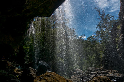
Forty Foot Falls
Continue along the track on the true left bank, crossing Kells Creek, and reaching a junction on the other side of Nattai Creek. Turn right and head up Nattai Creek for 150m to where the track drops down to the creek, and there are some great rocky slabs. From here you can see Forty Foot Falls about 50m upstream, assuming they are flowing. Cross over the creek, climb up a ladder, and follow a track to the foot of the falls, noting a track junction on your right that leads up to the top of the falls. The falls themselves are around 12m high, and are most impressive after significant rain.
Backtrack about 20m from the cave behind the falls to the track junction, and climb up to the top of the cliffline. If you want to get to the top of the falls, where they tumble over wide rock slabs, you'll need to detour off the track a little way. Otherwise, continue along the track for 300m to a T-junction with a fire trail. Follow this past a minor fire trail off to the right after 250m, and continue for another 750m (10 min) to a major fork. Keep right on a major fire trail, and after 250m you return to the Box Vale Tramway track near Casuarina Cutting. Turn left and follow the tramway back to the car park.
Related walks
Russells Needle
Time: 9 hrs Distance: 18 km Fitness: H Skill: MH Ascent: 700 m
Challenging walk with some scrambling to reach the top of an impressive knife-edge ridge
Ahearn Lookout
Time: 4 hrs Distance: 12 km Fitness: E Skill: EM Ascent: 80 m
A relatively easy walk to a spectacular lookout
Slott Way
Time: 5 hrs Distance: 11 km Fitness: EM Skill: EM Ascent: 450 m
A short steep route to the middle Nattai River, with views on the way in
Troys Creek Track
Time: 7 hrs Distance: 20 km Fitness: M Skill: EM Ascent: 440 m
A longish but relatively easy day to grassy flats on the Nattai River