| Time: | 2 days |
| Distance: | 23 km |
| Fitness: | EM |
| Skill: | EM |
| Ascent: | 430 m |
| Maps: | LPI Jenolan 8930-3N 1:25000 |
| Notes: | Print-friendly notes (opens in new window) |
Introduction
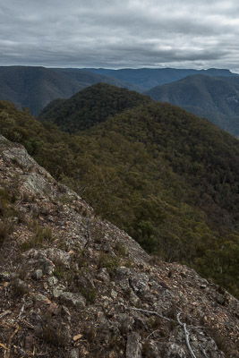
Views from Ironpot Mountain of Tinpot Mountain
This walk visits the scenic Lower Jenolan Gorge.
The walk is best in autumn or spring, though it can be done at any time of the year. In winter, the boulders in Breakfast Creek can be slippery, and the crossing of the Coxs and Jenolan Rivers can be very cold. In warmer months, you can wade or swim up through the gorge.
Some of the walk is off track, and some navigation is needed to descend Quartpot Ridge. There is some easy rock scrambling in a couple of places.
Access
The walk starts and finishes at Dunphys Camping Area, past Carlons Farm. To get there, drive to Blackheath, and take the left turn (coming from Katoomba) across the railway line at the traffic lights in town. Turn left again immediately, and then take the first right. After about 700m take a left turn, following the sign to Megalong Valley. The road is windy for the next few kilometres. About 13km after the turnoff you cross Megalong Creek at the Old Ford Reserve bridge. Continue along the (now unsealed) road for about 7km, through a couple of gates to reach the old farmhouse of Green Gully. Cross the bridge and head up the hill on the other side. At the T-junction at the top, turn left, and the parking area is at the top of the next hill.
Track notes
From 16 Jul 2016, last checked 16 Jul 2016
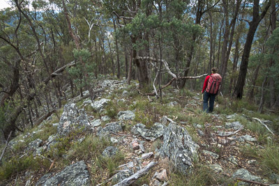
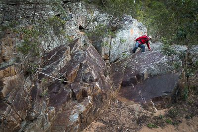
Descending Quartpot Ridge
To start, walk back down the hill you just drove up, and continue up the fire trail on the other side. Follow this for 1km (15 minutes) to a stile on your left (MGA427576), and climb over this on to an old fire trail. Follow this for another 1km (15 minutes), and veer left at a saddle (MGA419572) on to a foot track that leads up to Ironpot Mountain. There is a small scramble to get through a little cliffline.
The top of Ironpot Mountain is easy and pleasant walking through open woodland, with occasional conglomerate outcrops. The track passes near the northern cliffline, with good views down into the Coxs River valley far below. Continue west past the turnoff to the south to Ironmonger Hill. Beyond here the track becomes more vague.
Navigate north west down the ridge and then over a knoll to the twin hump of Tinpot Mountain. Head north off the second hump down the ridge towards Quartpot Gully, which has good views down to the Coxs River 500m below. Before you go too far, veer north east briefly to gain the narrow ridge to the north of the gully. This is steep but scenic, with the large quartzite boulders typical of the more vertical ridges. Lower down it flattens and becomes more grassy, finishing up at a large grassy clearing on the Coxs River.
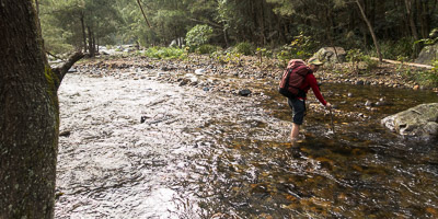
A chilly crossing of the Jenolan River
Turn left and make your way down the river. There is a track for much of the distance, formed by a combination of bushwalkers, cattle and other animals. Pass through a gate into the national park at MGA380576, and continue around the bottom of the Grand Bluffs to near the Jenolan River junction. Cross the Coxs River at around GR 382565, and walk across the flat area between the Coxs and Jenolan Rivers.
There are a number of options for camping. One nice spot is right next to the Jenolan River, at the foot of the ridge between the two rivers. Alternatively, walk up the northern bank of the Jenolan River, and cross over to the south side when that bank runs out. The Lower Jenolan River campsite is another 150m further on, and can be found on the sharp bend at GR 380564. There are also some other options closer to the Coxs River if you look around.
The next day, cross over the Jenolan River and continue downstream on the western bank of the Coxs River. This has a couple of scrambling sections, but is mostly easy walking. Find a convenient spot to cross the river between Goolara Gully and Breakfast Creek. Somewhere between 300m and 600m upstream from the Breakfast Creek junction is probably best, to avoid bouldery sections on the eastern bank.
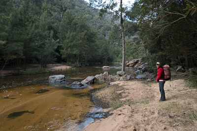
Looking for a shallow spot to cross the Coxs River
From the Breakfast Creek junction there are a variety of ways home. The described route is up Breakfast Creek, though Ironmonger Hill would be a better option if Breakfast Creek is up or it has been wet, to avoid slippery creek crossings. And if you want a harder route, you can climb Blue Dog Ridge to Knights Deck, which adds an extra 500m of ascent and descent.
Head up Breakfast Creek on the track, which crosses the creek numerous times. It can be slow going as it is not always obvious where the crossings are. Eventually you reach a large clearing at MGA412255, which is Frying Pan Flat. From here, the track climbs up over the spur away from the creek, before dropping down again to the creek. After crossing, it climbs up on to the large knoll in the middle of the U-bend, the Frying Pan. After another crossing, it climbs up on to Cattle Dog Ridge, before passing through a gate and then dropping back to creek level near Blackhorse Creek. The last 600m or so to Carlon Creek involve a number of creek crossings as the track stays near creek level.
Head up Carlon Creek on a track. Carlon Creek is well known for stinging nettles, so long pants are advisable. Near the top of the creek, the track swings out of the creek and around to the east on a fire trail. After about 500m, this fire trail swings sharply left (north east) on to another fire trail, and a further 500m brings you out at the stile at the bottom of the hill below Dunphys Camping Area. Turn right and walk back up the hill to the car.
Scrambling along the bank of the Coxs River
Related walks
Kanangra to Carlon's Farm (Green Gully)
Time: 3 days Distance: 36 km Fitness: M Skill: M Ascent: 1380 m
A variant on one of the classic Blue Mountains walks - finishing at Carlon's Farm below Blackheath, rather than at Katoomba
Breakfast Creek and Ironmonger Hill
Time: 5 hrs Distance: 13 km Fitness: M Skill: M Ascent: 600 m
A good introduction to the Wild Dog Mountains. Some creek hopping and ridge walking add variety to some spectacular scenery.
Tarros Ladder and Carlon Head
Time: 5 hrs Distance: 16 km Fitness: M Skill: H Ascent: 500 m
A challenging walk visiting two of the climbing passes of Narrow Neck
Coxs River - Six Foot Track
Time: 5 hrs Distance: 14 km Fitness: E Skill: E Ascent: 290 m
A pleasant, easy walk to one of the most accessible sections of the Coxs River
Splendour Rock
Time: 2 days Distance: 24 km Fitness: EM Skill: M Ascent: 640 m
A walk with lots of variety, visiting a famous lookout and home of the Bushwalkers War Memorial
Knights Deck
Time: 8 hrs Distance: 16 km Fitness: MH Skill: M Ascent: 1080 m
An excellent walk visiting two spectacular lookouts in the Wild Dog Mountains
Mt Mouin
Time: 6 hrs Distance: 15 km Fitness: M Skill: EM Ascent: 640 m
A solid walk to one of the highest of the peaks in the Wild Dogs, with great views