| Time: | 5 hrs |
| Distance: | 14 km |
| Fitness: | E |
| Skill: | E |
| Ascent: | 290 m |
| Maps: | LPI Hampton 8930-4S 1:25000 |
| Notes: | Print-friendly notes (opens in new window) |
Introduction
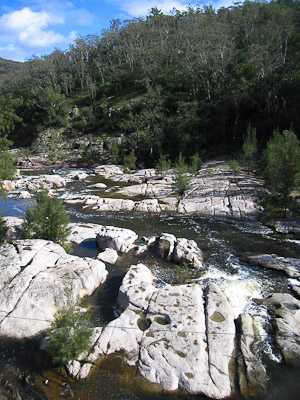
Coxs River flows over granite slabs
The Six Foot Track is one of the iconic Blue Mountains tracks. Originally built in 1884 as a bridle trail from Katoomba to Jenolan Caves, it is now a popular walk. Usually done over 3 days, shorter walks can be done in various sections of the track. The walk from the Megalong Valley Road down to the Coxs River is one of those shorter walks.
This walk can also be done as a very easy overnight walk, camping at the Coxs River Camping Area.
Access
The walk starts from the Six Foot Track crossing on the Megalong Valley Road.
To get there, drive to Blackheath, and take the left turn (coming from Katoomba) across the railway line at the traffic lights in town. Turn left again immediately, and then take the first right. After about 700m take a left turn, following the sign to Megalong Valley. The road is windy for the next few kilometres. About 13km after the turnoff you cross Megalong Creek at the Old Ford Reserve bridge. Continue for another 500m and park at the parking area on the right shortly before the road becomes unsealed.
Track notes
From 14 Mar 2009, last checked 29 May 2009
Start the walk by climbing over the stile and heading down the farm road. The route follows the road for just over a kilometre to a sign where you should turn off to the right on to a foot track. This quickly crosses a small creek at a bridge. The track climbs over a couple of hills before descending steeply to another creek. The section just before the creek can often be muddy and slippery.
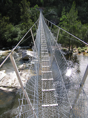
Bowtells Swing Bridge
Once across the creek, the track largely contours around the hills, dipping in and out of the gullies for the next 4km. The farm is largely left behind and the track traverses the bush. After a couple of kilometres you should be able to look down to your right and see the granite gorge of the Coxs River some way below you. As the track gets close to the river, there are a couple of spots where you can walk down on to the granite slabs and to the edge of the river.
A little further along you reach Bowtells Bridge, a swing bridge of cable and wire. It crosses the Coxs River at a height of about 10m. If the Coxs River is flowing strongly you will need to cross here as crossing down at the ford will be difficult, if not dangerous. In this case turn left on the far side and follow the track staying close to the river. After a kilometre you will reach the Coxs River Camping Area.
If the river is low, you can continue along the east bank for another kilometre to a large grassy clearing, and wade across the river to the camping area at the ford.
After a break for lunch at the camping area, retrace your steps back to the car.
Related walks
Breakfast Creek and Ironmonger Hill
Time: 5 hrs Distance: 13 km Fitness: M Skill: M Ascent: 600 m
A good introduction to the Wild Dog Mountains. Some creek hopping and ridge walking add variety to some spectacular scenery.
Splendour Rock
Time: 2 days Distance: 24 km Fitness: EM Skill: M Ascent: 640 m
A walk with lots of variety, visiting a famous lookout and home of the Bushwalkers War Memorial
Lower Jenolan River
Time: 2 days Distance: 23 km Fitness: EM Skill: EM Ascent: 430 m
A good overnight walk exploring some of the ridges and valleys of the Wild Dogs