| Time: | 2 days |
| Distance: | 24 km |
| Fitness: | EM |
| Skill: | M |
| Ascent: | 640 m |
| Maps: | LPI Jamison 8930-2N 1:25000 |
| LPI Jenolan 8930-3N 1:25000 | |
| Myles Dunphy Gangerang and Wild Dog Mountains Sketch Map 1:31680 | |
| Sketch maps: | Sketch map 1 PDF |
| Sketch map 2 PDF | |
| Notes: | Print-friendly notes (opens in new window) |
Introduction
On the Wombat Parade on the east side of Mt Warrigal
Splendour Rock in the Wild Dog Mountains is an impressive lookout at the southern end of Mt Dingo. It is the site of the Bushwalkers War Memorial, chosen because "the eye is drawn to the glory of Kanangra Walls, surely the spiritual home of bush walkers". A service is held here at dawn on Anzac Day.
This overnight loop walk follows a variety of fire trails, tracks and routes to a high camp on Mt Dingo. There is a bit of navigation and scrambling required. It is best during winter as water needs to be carried for the first day and a bit.
Access
The walk starts and finishes at the Dunphy Camping Area, formerly Carlons Farm, in the Megalong.
To get there, drive to Blackheath, and take the left turn (coming from Katoomba) across the railway line at the traffic lights in town. Turn left again immediately, and then take the first right. After about 700m take a left turn, following the sign to Megalong Valley. The road winds down into the creek for the next few kilometres. About 13km after the turnoff you cross Megalong Creek at the Old Ford Reserve bridge. Continue along the (now unsealed) road for about 7km, through a couple of gates to reach the old farmhouse of Green Gully. Cross the bridge at Galong Creek and head up the hill on the other side. At the T-junction at the top, turn left, and the camping and parking area is at the top of the next hill.
Track notes
From 13 Aug 2010, last checked 24 Apr 2016
Day 1: Dunphy Camping Area - Splendour Rock (13km, 320m ascent)
From the parking area, cross the stile at the south east corner, and continue up the steep hill along the Bellbird Ridge Management Trail.The track soon flattens, and it is about 20 minutes walk (1.3km) to a major junction with the Medlow Gap Management Trail. Turn right on the Medlow Gap Management Trail, and follow this as it winds around for 5.5km to a large clearing at Medlow Gap. There are good views of Narrow Neck and Clear Hill to your left, particularly in the vicinity of the Breakfast Creek crossing.
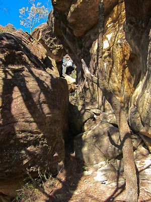
The pass up on to Mt Merrimerrigal is through this tunnel
Water can be picked up from where the fire trail crosses Breakfast Creek. There is unlikely to be water from here until the following morning.
At Medlow Gap, turn right and follow the fire trail through a locked gate to the west. Continue along the fire trail for 600m towards Mt Mouin, keeping an eye out for a cairn and a foot track off to the right. Turn on to this, a narrow and occasionally overgrown track that undulates along the foot of Mt Mouin. After 1.5km, a short climb on to Black Horse Ridge brings you to a cairn at a clearing, with tracks heading in 5 directions. Take the track to the south, which crosses a small gully before climbing up to the saddle at Blackhorse Gap.
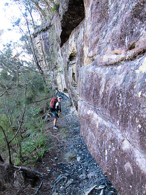
Turn right (WSW), following the ridge up via a short scramble to the lower cliffline of Mt Warrigal, and then head left under the eastern cliffs. Take care, as the area gets little sun, and the track (known as the Wombat Parade) is often sloping and quite slippery. In general, stay as high as possible, keeping just under the cliffline itself. As you reach the south end of Mt Warrigal, there are good views to the west.
Cross the saddle, climbing up towards Mt Merrimerrigal, and then stay right under the cliffs on the west for about 100m, along a narrow ledge. Where the track appears to peter out, look up and back to your left, and scramble up through a small tunnel to the top of the cliffs. Continuing south through the casuarina forest brings you to a large open rocky platform known whimsically as the Playground of the Dingoes. Tracks are indistinct on the plateau, so navigate towards the south east corner of Mt Merrimerrigal, and pick up the narrow ridge that runs all the way to Dingo Gap.
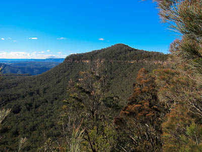
Mt Warrigal
Climb down into Dingo Gap, and follow the track up the hill to the top of Mt Dingo, where there is a good camp site. Continue down the track to the point, and Splendour Rock, noting a number of smaller campsites on the way. Splendour Rock is right at the southern end of Mt Dingo, commanding spectacular views of the Coxs River and the Gangerang Range on the other side. Lake Burragorang can also be seen to the east. There is a log book and the Bushwalkers War Memorial plaque. If you descend the small gully to the west of Splendour Rock, you can take a look at Thommos Chains in a small tunnel to the left. These allow an exposed descent of the southern end of Mt Dingo.
Find a campsite anywhere between Splendour Rock and the summit of Mt Dingo.
Day 2: Splendour Rock - Dunphy Camping Area (11km, 320m ascent)
The next day, please leave your campsite tidy and in good order for future visitors.
Head back along the track towards Mt Dingo, but keep an eye out for another track branching off to the left, just before the main track climbs up the steep bit of the hill to the summit. This track contours along the slopes of Mt Dingo out to the cliff edge on the western side, which looks impressive and imposing. The pass down however is reasonably straightforward, with only a little scrambling or exposure. Continue down to the main track at a T-intersection and turn right. It is about half an hour to Mobbs Swamp, a large clearing and camping area. Water here is fairly reliable except after dry spells, but can sometimes be hard to find. It is best obtained from where the creek crosses the track about 100m NE of camping area, but you may need to go downstream for a distance to find pools if it is not flowing.
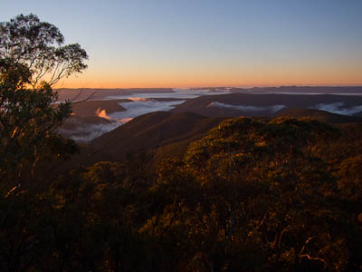
Sunrise from Splendour Rock
Another 10 mins (700m) brings you to a 3 way junction. The left branch heads out along Blue Dog Ridge, so take the right hand branch. 15 mins further along brings you back to the 5 way intersection on top of Black Horse Ridge. Take either of the two tracks to the left (north), as they rejoin after about 150m. Black Horse Ridge is pleasant and easy going for almost 2km, rising towards the end, just before a knee jarring 400m descent to Breakfast Creek. At a clearing on the high point of the ridge, note a track off to the left. This leads to the pass off the ridge. Before descending, continue straight ahead to where the the conglomerate cliffs jut out over the steep slopes below, and enjoy the excellent views of the upper Breakfast Creek Valley.
Return to the clearing and take the track towards the pass, following it through the cliffs and steeply down to Breakfast Creek, a 400m descent. Cross over Breakfast Creek at the bottom, and turn right on to a distinct track, which shortly heads left up Carlon Creek. Carlon Creek is famed for its stinging nettles, so long pants are a good idea for this section. The track crisscrosses Carlon Creek all the way to the top, where it climbs out up a steep overgrown fire trail. At the top of the fire trail, turn left at a T-intersection and follow this back to a stile. Climb over the stile, turn right, and walk up the hill back to the Dunphy Camping Area.
Alternative routes
There are various other ways of reaching or returning from Splendour Rock. The best idea is to get hold of Myles Dunphy's Gangerang and Wild Dog Mountains Sketch Map, as most of the tracks in the area are marked.
The quickest way in is via the fire trail, but continuing on the lower track around Mt Warrigal, and climbing up the the west ridge of Mt Dingo.
On track, a good alternative exit route is via Blue Dog Ridge and Knights Deck, and either Breakfast Creek or Ironmonger Hill. This adds some 7km and an extra 300m of climbing and descending.
Many of the other ridges on both the north and south side of Breakfast Creek are negotiable. Experienced walkers may wish to investigate these. There are typically no tracks.
For those who are uncomfortable with the scrambling and sidling on the first day, the second day's route can be taken in both directions.
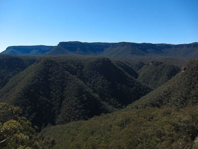
View of Breakfast Creek and Narrow Neck from the end of Blackhorse Ridge
Related walks
Kanangra to Carlon's Farm (Green Gully)
Time: 3 days Distance: 36 km Fitness: M Skill: M Ascent: 1380 m
A variant on one of the classic Blue Mountains walks - finishing at Carlon's Farm below Blackheath, rather than at Katoomba
Kanangra to Katoomba
Time: 3 days Distance: 45 km Fitness: MH Skill: M Ascent: 1350 m
An excellent crossing of the southern Blue Mountains with a variety of scenery
Breakfast Creek and Ironmonger Hill
Time: 5 hrs Distance: 13 km Fitness: M Skill: M Ascent: 600 m
A good introduction to the Wild Dog Mountains. Some creek hopping and ridge walking add variety to some spectacular scenery.
Tarros Ladder and Carlon Head
Time: 5 hrs Distance: 16 km Fitness: M Skill: H Ascent: 500 m
A challenging walk visiting two of the climbing passes of Narrow Neck
Dunphys Pass and Harmil Ledge
Time: 6 hrs Distance: 10 km Fitness: EM Skill: MH Ascent: 490 m
An excellent walk along two of the shale ledge passes of Narrow Neck, with great views on a clear day
Coxs River - Six Foot Track
Time: 5 hrs Distance: 14 km Fitness: E Skill: E Ascent: 290 m
A pleasant, easy walk to one of the most accessible sections of the Coxs River
Knights Deck
Time: 8 hrs Distance: 16 km Fitness: MH Skill: M Ascent: 1080 m
An excellent walk visiting two spectacular lookouts in the Wild Dog Mountains
Mt Mouin
Time: 6 hrs Distance: 15 km Fitness: M Skill: EM Ascent: 640 m
A solid walk to one of the highest of the peaks in the Wild Dogs, with great views
Lower Jenolan River
Time: 2 days Distance: 23 km Fitness: EM Skill: EM Ascent: 430 m
A good overnight walk exploring some of the ridges and valleys of the Wild Dogs
Personal reports
25/04/2017 - Anzac Day at Splendour Rock: Dunphys Camping Area - Medlow Gap - Yellow Dog Track - Splendour Rock - Mt Merrimerrigal - Mt Warrigal - Mt Mouin - Medlow Gap - Dunphys Camping Area [SBW][L] (report | photos)
24-25/04/2016 - Splendour Rock: Dunphys Camping Area - Medlow Gap - Yellow Dog Track - Splendour Rock (C) - Mt Merrimerrigal - Mt Warrigal - Mt Mouin - Medlow Gap - Dunphys Camping Area [SBW]: I arrived at Dunphys Camping Area at the same time as Angela Barton's SBW group, and so walked in with them for Anzac Day service at Splendour Rock, and enjoyed their company around the campfire. I headed out with them, and we picked up Karl Miller along Mt Warrigal. Karl and I separated from the party at Blackhorse Gap and went out via Mt Mouin. (photos)
13-14/08/2010 - Splendour Rock: Dunphy Camping Area - Bellbird Ridge FT - Medlow Gap FT - Medlow Gap - Blackhorse Gap - Warrigal Gap - Mt Merrimerrigal - Dingo Gap - Mt Dingo - Splendour Rock (C) - Mobbs Swamp - Black Horse Ridge - Breakfast Creek - Carlon Creek - Dunphy Camping Area (photos)