| Time: | 7 hrs |
| Distance: | 21 km |
| Fitness: | M |
| Skill: | E |
| Ascent: | 580 m |
| Maps: | LPI Hornsby 9130-4S 1:25000 |
| Notes: | Print-friendly notes (opens in new window) |
Introduction
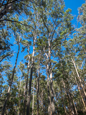
Blue Gum forest below Hornsby
The Great North Walk runs 240km from Sydney to Newcastle. Some of the most popular sections are in the bush between Hornsby and the Hawkesbury, and this section of the walk explores one of those. This is a longish section of the GNW, but it is quite varied with sections of creek walking, ridges, and the cliffs and slopes in between. Even though the total height difference is less than 200m, there are a reasonable number of small ups and downs, not all of which appear in the listed elevation.
The Great North Walk is marked along its length by a couple of different sorts of markers. The old style markers are white or beige round topped wooden posts, about 1m high, with arrows engraved in them. These point out the track in both directions. More recently these are being superseded by red square markers with a white walker on them, typically on green wooden posts with arrows pointing out the track. The track is usually marked only where necessary - at junctions, turns, or where the route is less clear.
Access
The walk is best accessed by train. It starts at Hornsby Station and finishes at Mt Ku-ring-gai Station.
You can also leave a car at one end and catch the train between those stations.
Track notes
From 03 Jun 2007, last checked 05 Apr 2015
A part of the track previously crossed the Danger Area of the Hornsby Rifle Range. This section of track has now been rerouted. However, it does take it out of the bush and on to streets for a short section, as well as increasing the descent/ascent, which used to be 19km/440m.

Crossing Berowra Creek at Fishponds
Head out of Hornsby Station on the west side, crossing two pedestrian crossings and then the Pacific Highway at the traffic lights. You'll see the first of the old style Great North Walk markers. Turn right following the marker, and then first left into Dural St. After 200m turn right into Quarry St. Just opposite the sign for the entry to the Hornsby Mountain Bike Trail, turn left on to a foot track that leads into the bush. This crosses over a fire trail, and descends the Hornsby Heritage Steps, built during the Depression, down to a clearing in the Berowra Valley Bushland Park at the end of Rosemead Rd.
Follow the Blue Gum Track out the other side of the clearing, cross the small creek, and then left on to another fire trail at a T-junction. This takes you up the hill, and past a lovely stand of Blue Gums and then casuarinas.
Down the hill, veer right off the fire trail on to a foot track, and as you head down the hill, turn right to take the detour that avoids crossing the rifle range. Unfortunately this route misses out on the section that goes through Fishponds Waterholes. It is still possible to continue to the waterholes as an out-and-back trip, but adds about a kilometre (if you climb up and over the ridge) and about 50m of descent/ascent.
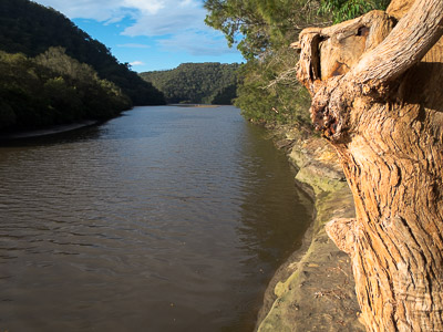
Berowra Creek below Crosslands
The detour track heads steeply up the hill to the end of Manor Rd. Follow Manor Rd up until it becomes Rosamund Rd, and then take the fourth left into Clarinda St. Pick up the fire trail at the end of Clarinda St, and follow it for about 15mins to a turnoff to the left on to a foot track. This descends steeply to a T-junction with the Quarry Trail, where you turn right.
This takes you after a few minutes to the Historic Steele Military Bridge. Named after Major General Sir Clive Steele, this was built in 1945-46, and is one of only a few remaining local examples of a Bailey Bridge.
Cross the bridge and head up the fire trail, which is steep in sections. About half an hour's walk brings you to the Tunks Ridge Rest Area, which has a pit toilet and basic camping facilities, but no water.
Turn right and follow the fire trail down Tunks Ridge. At an obvious Y-junction, either path can be taken, though the left makes more sense. Either way, the trails rejoin shortly at a signboard, where a foot track leaves to descend the final part of the ridge to the road at Galston Gorge. This track is very steep in places, with steps carved out of the rock. At one point there are metal feet and handholds put into the sandstone.
At the bottom, head right and down to the creek, where there is another set of stepping stones that cross under the bridge. Climb the track on the other side to the small car park at the bottom of the gorge, where the main track leaves.
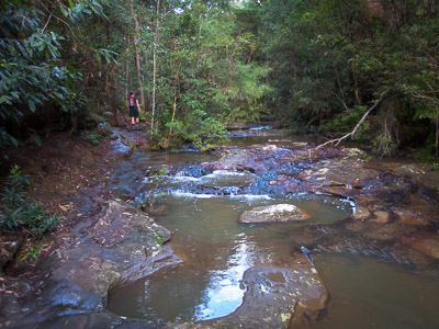
Climbing up Lyrebird Gully
From Galston Gorge, the track traverses along the right hand side of the creek, mostly at some height above the water. There are some excellent views where the track passes along the cliff tops. Then there is a quick descent back to the creek a little way upstream of Rockyfall Rapids. Calling them rapids is a little over the top except after significant rain, but they mark the upper bound of navigability for water craft in Berowra Creek. They are actually 250m upstream of where they are marked on the older maps (and not marked at all on some newer maps!).
It is pleasant walking along the now much wider creek to Crosslands Reserve, about 2.5km away. There are several nice camping spots in this section. Crosslands Reserve is a very large picnic and camping area that stretches for about 800m along the banks of Berowra Creek.
Near the north end of Crosslands Reserve, pick up the boardwalk on the right that crosses the swamp. The boardwalk turns into a track that follows the foreshore, and then climbs over a small ridge and down to the recently repairded Calna Creek bridge. Cross the bridge, turn right and follow the track up Calna Creek and Lyrebird Gully, passing some overhangs and a waterfall along the way. The track emerges on to a fire trail, and then an old road, which comes out at the junction of Glenview Rd and the Pacific Highway. Turn right, cross the highway on the footbridge, and turn left to get to Mt Kuring-gai Station.
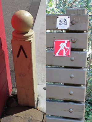
The two styles of Great North Walk signs next to each other
Related walks
Bairne Track and Towlers Bay Track loop
Time: 4 hrs Distance: 11 km Fitness: EM Skill: M Ascent: 200 m
A good loop walk with some rock-hopping in Ku-ring-gai Chase NP.
Collingridge Point
Time: 2 hrs Distance: 10 km Fitness: E Skill: E Ascent: 30 m
An easy walk along a flat ridge to a good lookout in Marramarra National Park.
Taffys Rock
Time: 6 hrs Distance: 15 km Fitness: M Skill: EM Ascent: 400 m
An excellent walk to a less visited part of Ku-ring-gai Chase, with excellent views from a number of lookouts
Hornsby to Thornleigh
Time: 4 hrs Distance: 11 km Fitness: E Skill: E Ascent: 200 m
A fairly easy section of the Great North Walk through varied terrain
Turramurra to Berowra
Time: 4 hrs Distance: 13 km Fitness: EM Skill: E Ascent: 200 m
A relatively easy and pleasant walk along Cowan Creek, although marred a bit by the motor boats on the creek.
Resolute Track Loop
Time: 3 hrs Distance: 8 km Fitness: E Skill: E Ascent: 180 m
A good walk in summer with some interesting aboriginal sites and numerous lookouts.
Wahroonga to Mt Kuring-gai
Time: 5 hrs Distance: 15 km Fitness: EM Skill: E Ascent: 200 m
A great variety of scenery on this creek and ridge walk through Ku-ring-gai Chase
Cowan to Mt Kuring-gai
Time: 6 hrs Distance: 17 km Fitness: M Skill: E Ascent: 680 m
One of the best sections of the Great North Walk, with views, foreshore walking, creek crossings and open ridges.
Personal reports
05/04/2015 - Hornsby to Mt Kuring-gai: Hornsby Station - Fishponds - Tunks Ridge - Galston Gorge - Berowra Creek - Crosslands - Calna Creek - Lyrebird Gully - Mt Kuring-gai Station (photos)
03/06/2007 - Hornsby to Mt Kuring-gai: Hornsby Station - Fishponds - Tunks Ridge - Galston Gorge - Crosslands - Mt Kuring-gai Station: A longish pleasant section of the Great North Walk (report | photos)