| Time: | 5 hrs |
| Distance: | 15 km |
| Fitness: | EM |
| Skill: | E |
| Ascent: | 200 m |
| Maps: | LPI Hornsby 9130-4S 1:25000 |
| Notes: | Print-friendly notes (opens in new window) |
Introduction
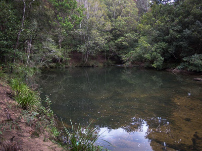
One of the Gibberagong Waterholes on Cockle Creek, at the junction with Lovers Jump Creek
The walk from Wahroonga to Mt Kuring-gai via the Gibberagong Track has a great variety of scenery, from open ridge tops to rocky creeks to bays and estuaries. Cockle Creek is one of the prettier creeks in Ku-ring-gai Chase NP, and the Gibberagong Track follows it for some distance. The walk is good all year round, though the rocks on the Gibberagong Track may be more slippery than usual in winter. Spring is good for the wildflowers, and summer for a possible swim, though the climb up to Mt Kuring-gai is tougher in the heat.
Once at Bobbin Head, other finishes to the walk are possible, including to Turramurra (via the Bobbin Head Track or via Warrimoo/Sphinx tracks), or to Berowra (via the Berowra Track).
Access
The walk as described starts at Wahroonga Station, on the North Shore Line. It is about 30-40 minutes of walking from the station - just under 3km - through the streets of North Wahroonga to the start of the track.
The walk is quite pleasant and there is generally little traffic.
The 576 and 576T bus services do run from Wahroonga Station to the end of Grosvenor Rd, where the track starts, but they are not particularly frequent, and don't operate on weekends.
Track notes
From 21 Oct 2001, last checked 01 Sep 2019
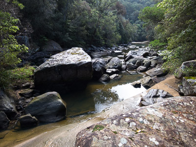
Rocky rapids before the tidal section of Cockle Creek
Exit Wahroonga Station, and turn left on to Redleaf Ave which immediately becomes Illoura Ave. Follow Illoura Ave along the top of Wahroonga Park to the next four-way intersection, and turn right on to Stuart St. At the T-junction, turn left on to Cleveland St. At the end of Cleveland St turn right on to Burns Rd and immediately left in to Grosvenor St. Follow Grosvenor St right to the very end where a locked gate leads on to a fire trail. Ignore tracks and fire trails off to the left and right just before the end of the road. Note that there is no footpath for the last kilometre or so of Grosvenor St.
The Gibberagong Fire Trail winds through pleasant open forest for about 20-30 minutes before turning into a foot track. Just before the foot track starts you can turn off to the right for a short distance where there is a lookout that might be a good spot for an early morning tea.
Back at the track, it zigzags gently down the hill, ending up at Lovers Jump Creek near the junction with Cockle Creek. Cross Lovers Jump Creek on steps carved into boulders on either side of the creek. If there has been recent rain, this will mean wet feet, but you can head upstream for another 10m or so for a dry but slippery crossing. Pick up the track on the other side of the creek and follow it downstream (left).
Aboriginal grinding grooves
Immediately a large pool, the first of the Gibberagong Waterholes, gives you some idea of how beautiful the creek would have been before being somewhat spoilt by urban runoff. A short distance further on, ignore a turnoff to the right that leads up the hill to Murrua Rd, and follow the signed track to Bobbin Head. The other of the Gibberagong Waterholes is on your left. The waterholes are pretty, and may be a good spot for a swim in summer, but keep in mind that these run off civilisation and avoid swimming after recent rain due to pollution.
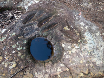
A little further along the track, a couple of overhangs provide shelter in case of rain. The track undulates along the right hand bank, sometimes at creek level, sometimes up to 20m above the creek on ledges and slopes, before flattening out in the lower tidal reaches. There are a few spots on the track that require clambering over boulders. After meandering around the tidal reaches, the track climbs up to a junction, where the right fork leads to the rainforest, and the other down to Bobbin Head. The rainforest is only a short detour out and back, but is not that different to what you have already seen in the upper reaches of the Gibberagong Track. Whether you opt to go there or not, then take the Bobbin Head fork. Just after this junction, it is worth taking the very short signposted detour to a rocky outcrop with aboriginal axe grinding grooves.
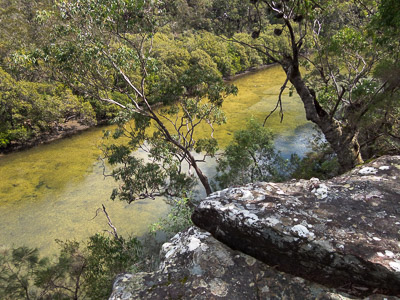
Cockle Creek from nearby rocky outcrops
On the way up the next little rise, there are a couple of rock platforms off to the left that have splendid views over Cockle Creek, a good spot for lunch if you are looking to get away from the crowds at Bobbin Head. There are also some more rock platforms on the right past the top of the rise.
Follow the track down through a cleft on to the boardwalk, which winds around through the mangroves before crossing Cockle Creek on a suspension bridge. Continue along the path into Bobbin Head, where there are toilets, shelters, barbeques and picnic tables, as well as two cafes/kiosks.
At the main road, turn left and walk for 150m up the road past the Bobbin Inn and Visitors Centre to the signposted turnoff to the Birrawanna Track. Leave the road and climb up the steep stairs to the ridge. At the top of the ridge, a vague track heads off right towards what is probably the Cockle Creek Lookout, but the track is unmarked, tends to peter out, and the views are somewhat underwhelming. Continue along the track to a junction near a large building, the NPWS regional office, where the Birrawanna Track heads off to the left.
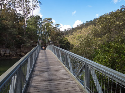
Bridge across Cockle Creek
Continue straight ahead through the car park for the regional office, cross over the road and pick up the track that leads down to Apple Tree Bay from the left hand end of the clearing. At the road at the bottom turn left and walk 100m down the road to Apple Tree Bay, where there is a kiosk, probably only open weekends, toilets and a few picnic tables. Head across the bay to the footbridge. Turn right and follow the track along the foreshore. A little way along the track splits and then rejoins itself. Another 10 minutes or so, a set of stairs and a sign mark the start of the Mt Kuring-gai Track. Turn left, and follow the track as it zigzags up the hill. A small platform most of the way up to the ridge provides some views and a spot to catch your breath if need be. The track soon reaches the ridge top and heads along through mostly open forest.
Just before reaching the final fire trail section, the track hits a small cliff face, sidles alongside to the left, and up a set of stone stairs. It is worth turning right at the top of these stairs and heading out to the top of the cliff for great views. Return to the main track, which quickly turns into a fire trail and walk 10-15 mins to the barrier at the end of the fire trail.
To get to the station, follow the road, Harwood Ave, up the hill to the end, and cross the freeway on a footbridge.
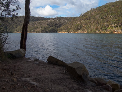
Cowan Creek from the foreshore track
Related walks
Bairne Track and Towlers Bay Track loop
Time: 4 hrs Distance: 11 km Fitness: EM Skill: M Ascent: 200 m
A good loop walk with some rock-hopping in Ku-ring-gai Chase NP.
Resolute Track Loop
Time: 3 hrs Distance: 8 km Fitness: E Skill: E Ascent: 180 m
A good walk in summer with some interesting aboriginal sites and numerous lookouts.
Bobbin Head Loop
Time: 3 hrs Distance: 9 km Fitness: E Skill: E Ascent: 180 m
A pleasant walk along scenic Cowan Creek to Bobbin Head, and then back via the ridge.
Hornsby to Mt Kuring-gai
Time: 7 hrs Distance: 21 km Fitness: M Skill: E Ascent: 580 m
An enjoyable section of the Great North Walk with varied terrain
Taffys Rock
Time: 6 hrs Distance: 15 km Fitness: M Skill: EM Ascent: 400 m
An excellent walk to a less visited part of Ku-ring-gai Chase, with excellent views from a number of lookouts
Turramurra to Berowra
Time: 4 hrs Distance: 13 km Fitness: EM Skill: E Ascent: 200 m
A relatively easy and pleasant walk along Cowan Creek, although marred a bit by the motor boats on the creek.
Cowan to Mt Kuring-gai
Time: 6 hrs Distance: 17 km Fitness: M Skill: E Ascent: 680 m
One of the best sections of the Great North Walk, with views, foreshore walking, creek crossings and open ridges.
Mt Murray Anderson
Time: 4 hrs Distance: 12 km Fitness: E Skill: EM Ascent: 70 m
Spectacular views of Cowan Creek and aboriginal rock engravings on this flat but rough walk
Personal reports
05/09/2014 - Wahroonga to Mt Kuring-gai: Wahroonga Station - Gibberagong Track - Gibberagong Waterholes - Bobbin Head - Birrawanna Track - Apple Tree Bay - Berowra Track - Mt Kuring-gai Track - Mt Kuring-gai Station (photos)