| Time: | 3 hrs |
| Distance: | 9 km |
| Fitness: | E |
| Skill: | E |
| Ascent: | 180 m |
| Maps: | LPI Hornsby 9130-4S 1:25000 |
| Notes: | Print-friendly notes (opens in new window) |
Introduction
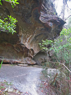
Large overhang near the track, with an aboriginal midden
This walk follows the Sphinx and Warrimoo Tracks along scenic Cowan Creek to Bobbin Head, and then returns via the Bobbin Head Track along the ridge to the park entrance.
Access
The start of the walk is at the Sphinx, near the end of Bobbin Head Rd in Turramurra, just before the road enters Ku-ring-gai Chase National Park. If you are using public transport, catch the bus from Turramurra Station to the Sphinx. The buses are relatively infrequent so check timetables.
Track notes
From 25 Feb 2007, last checked 25 Feb 2007
From the park entrance at the top of the Bobbin Head Rd, take the road to the right down to the Sphinx. Follow the sealed track from the Sphinx for about 30m, and turn right at the T-intersection. Turn left shortly after, following the Sphinx/Warrimoo Track sign down steeply down to a small creek. The track follows the small creek down to Cowan Creek, passing a number of twisted old Angophora costata (Smooth-Barked Apple) along the way. At the bottom turn left, and follow the well-formed track along Cowan Creek. The track winds in and out of a few bays along the way. It also passes an old aboriginal midden where a large cave overhangs the water. After about 3.5km along the creek you pass a sign to the Bobbin Head track.
If you have time, press on for 200m onto a sealed track behind the back of the marina and cross the bridge to Bobbin Head picnic area, a nice spot for a break. By wandering to the end of the car park you can follow the Gibberagong Track for about 10 minutes to visit some aboriginal engravings and rock art. Return back to the signposted track past the marina and climb up on to Bobbin Head Ridge.
After a steep climb for the first kilometre, including some switchbacks, the ridge flattens out and it is easy walking along a fire trail back to the park entrance.
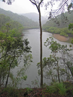
Looking downstream on Cowan Creek from the walking track
Related walks
Bairne Track and Towlers Bay Track loop
Time: 4 hrs Distance: 11 km Fitness: EM Skill: M Ascent: 200 m
A good loop walk with some rock-hopping in Ku-ring-gai Chase NP.
Turramurra to Berowra
Time: 4 hrs Distance: 13 km Fitness: EM Skill: E Ascent: 200 m
A relatively easy and pleasant walk along Cowan Creek, although marred a bit by the motor boats on the creek.
Wahroonga to Mt Kuring-gai
Time: 5 hrs Distance: 15 km Fitness: EM Skill: E Ascent: 200 m
A great variety of scenery on this creek and ridge walk through Ku-ring-gai Chase
Taffys Rock
Time: 6 hrs Distance: 15 km Fitness: M Skill: EM Ascent: 400 m
An excellent walk to a less visited part of Ku-ring-gai Chase, with excellent views from a number of lookouts
Mt Murray Anderson
Time: 4 hrs Distance: 12 km Fitness: E Skill: EM Ascent: 70 m
Spectacular views of Cowan Creek and aboriginal rock engravings on this flat but rough walk