| Time: | 2 hrs |
| Distance: | 10 km |
| Fitness: | E |
| Skill: | E |
| Ascent: | 30 m |
| Maps: | LPI Cowan 9130-4N 1:25000 |
| Notes: | Print-friendly notes (opens in new window) |
Introduction

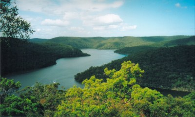
Berowra Creek from the lookout at Collingridge Point
Marramarra National Park is one of the less well known national parks in the Sydney region. This walk is a good introduction, with an easy walk to a pleasant lookout over Berowra Creek and Joe Crafts Bay.
Access
Track notes
From 24 Feb 2002, last checked 24 Feb 2002
The walk is quite straightforward. Continue along the main fire trail passing minor fire trails to the north and south after about 2 km, and some more minor trails to the south after about 3.5km. At about 4 km you will reach a major junction. The left fork heads towards Coba Point. Take the right fork. Less than a kilometre further on you reach the lookout above Collingridge Point. To return, simply retrace your steps.
If you have time it may be worth exploring some of the other fire trails off to the north and south of the main trail. The one to the north after about 2km has some good views.
Related walks
Hornsby to Mt Kuring-gai
Time: 7 hrs Distance: 21 km Fitness: M Skill: E Ascent: 580 m
An enjoyable section of the Great North Walk with varied terrain
Taffys Rock
Time: 6 hrs Distance: 15 km Fitness: M Skill: EM Ascent: 400 m
An excellent walk to a less visited part of Ku-ring-gai Chase, with excellent views from a number of lookouts
Mt Murray Anderson
Time: 4 hrs Distance: 12 km Fitness: E Skill: EM Ascent: 70 m
Spectacular views of Cowan Creek and aboriginal rock engravings on this flat but rough walk
Smugglers Ridge
Time: 4 hrs Distance: 14 km Fitness: E Skill: E Ascent: 200 m
A pleasant walk along easy fire trail and track with some views and aboriginal engravings
Personal reports
24/02/2002 - Collingridge Point: (report)