| Time: | 2 hrs |
| Distance: | 6 km |
| Fitness: | E |
| Skill: | E |
| Ascent: | 280 m |
| Maps: | LPI Colo Heights 9031-3N 1:25000 |
| LPI Mountain Lagoon 9031-3S 1:25000 | |
| Sketch maps: | Sketch map 1 PDF |
| Notes: | Print-friendly notes (opens in new window) |
Introduction

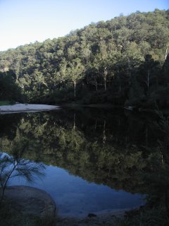
Morning at the lovely swimming hole at the bottom of Bob Turners Track to the Colo River
The Colo River flows through the heart of the Wollemi Wilderness area, one of the biggest areas in the state. In most places in the wilderness, the Colo is lined by steep cliffs, and routes into the Colo are often precipitous. Bob Turners Track lies in the lower part of the river, and is one of the easiest access routes. It offers great swimming in summer on a pleasant sandy beach.
The original track was a pack horse track constructed by George Townsend (sometimes spelled "Townshend"), as part of the survey for his railway to cross the Blue Mountains by going up the Colo River. It was restored in 1970-71 by Bob Turner, a former mayor of Ku-ring-gai, and others, and named after him when Wollemi NP was declared in 1979.
Access
Drive north on the Putty Rd from Windsor, to the Ampol service station at Colo Heights, about 16km after the Colo River Bridge. After a further 500m turn left on to a fire trail, marked with an NPWS sign saying "Bob Turners Track". Follow the fire trail, keeping left at a junction after 700m, for about 3km to a parking area. There are NPWS signs at the track head. The fire trail used to be in good condition but is currently a bit rocky and rutted. Low slung cars will need to take care.
Track notes
From 24 Nov 2001, last checked 11 Oct 2015
Head down the track from the car park. In its early stages there has been plenty of track stabilisation work. The track heads down a ridge and winds back into a lovely gully, dominated by large Smooth-barked Apple (Angophora costata) and an understory of ferns. After descending the gully a little way, the track climbs out and on to the ridge. There are three more ridges, broken by three more progressively deeper gullies.
Note the changes in vegetation between the east and west sides of the gullies. The western sides of the gullies are much more open, while the more sheltered eastern sides, particularly lower down, have much more vegetation cover. The dominant species include Grey Ironbark (Eucalyptus paniculata), and Burrawang (Macrozamia sp) and Grass Tree (Xanthorrhoea sp). There are some impressive Deane's Gum (Eucalyptus deanei) in the last of the gullies.
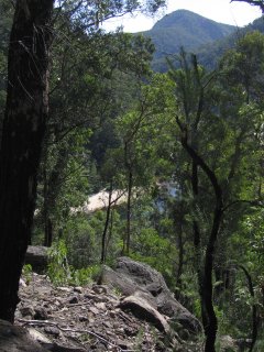
Crossing a small rise after climbing out of the last gully, you reach a hairpin bend, and the Colo River comes into view. If you are dying for a swim, it is not long now. One final steep zigzagging descent brings you to the junction of the Colo and Hungryway Creek.
Have lunch here and a swim in the beautiful pool if it is a sunny day. If you have time, you may like to explore upstream or downstream on the banks, although it can be slow going.
After a break, return to your car the same way.
If you decide to camp, it is probably best to treat the water from either the Colo or Hungryway Creek, as both have run-off from farms. The area can get quite popular, so please climb a good distance away from the river if you are going to the toilet.

First glimpses of the Colo River from Bob Turners Track
Related walks
Mountain Lagoon Loop via Colo Meroo and Tootie Creek
Time: 2 days Distance: 29 km Fitness: MH Skill: M Ascent: 520 m
A challenging river walk along the lower reaches of the Colo River.
Crawfords Lookout to Dooli Creek
Time: 2 days Distance: 21 km Fitness: M Skill: MH Ascent: 460 m
A challenging walk through some of the best scenery in the upper Colo River.
Canoe Creek
Time: 4 hrs Distance: 6 km Fitness: EM Skill: EM Ascent: 400 m
A relatively easy route to the magnificent Colo River, with good swimming and the option of camping.
Crawfords Lookout
Time: 2 hrs Distance: 8 km Fitness: E Skill: EM Ascent: 240 m
A short walk to a spectacular lookout over Wollemi Creek and the upper Colo River.
Colo Meroo
Time: 2 days Distance: 24 km Fitness: EM Skill: EM Ascent: 580 m
Good views of the Colo River on the way to this excellent camp ground by the river itself
Tootie Creek (T3 Track)
Time: 4 hrs Distance: 6 km Fitness: M Skill: EM Ascent: 500 m
A steep but short and spectacular walk to the Colo River at its junction with Tootie Creek
Personal reports
10-11/10/2015 - Bob Turners Track: Bludge trip down to the Colo River with Vivien, Emmanuelle and Justine, to test my foot out with an easy overnighter (photos)
21-22/04/2012 - Colo River Rafting: Bob Turners Track - Tootie Creek - Townsend Bend - Colo River (C) - Colo Meroo - Upper Colo Bridge (photos)
07/02/2010 - Bob Turners Track: Rachel and I walked in hoping to lilo the Colo despite there being a 5m flood. Perhaps unsurprisingly it was not to be! We blew up lilos, paddled out, and paddled back in about as quickly. No control at all. Still, impressive to see and to even venture out on. (report | photos)
13-14/10/2006 - Bob Turners Track: (photos)
24-25/11/2001 - Colo River Lilo: Bob Turners Track - Colo River - Tootie Creek - Bob Turners Track (report)
Links
 Sydney and Beyond, Andrew Mevissen
A reasonable variety of walks with good descriptions, but let down by the maps and the lack of index
 The Colo Gorge - Anthony Dunk
A useful personal site with varied information on aspects of the Colo River area in Wollemi NP