| Time: | 2 days |
| Distance: | 18 km |
| Fitness: | M |
| Skill: | MH |
| Ascent: | 460 m |
| Maps: | LPI Nerriga 8927-4N 1:25000 |
| LPI Touga 8928-3S 1:25000 | |
| Notes: | Print-friendly notes (opens in new window) |
Introduction
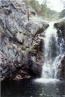
The last cascade ... an alternative route!
The Ettrema region is a Wilderness area. There are very few formed tracks, and significant amounts of scrambling and route finding can be expected. As a result, specific track notes will not be given on this web site. Some general information on routes will be presented and several two and three day trips suggested. This should be sufficient for experienced walkers to plan trips of various lengths. Ettrema is not a place for inexperienced walkers to learn skills.
Access
To get to the Ettrema area you have a couple of options. With the improvements to the Princes Hwy down the South Coast, the best route will largely depend on where in Sydney you are coming from.
From the Hume Hwy on the way to Goulburn, take the turnoff to Bungonia State Conservation Area, just past the big petrol stations at Marulan. Continue through Bungonia, and then Windellama, crossing the Shoalhaven River at the bridge at Oallen Ford. Turn left towards Nerriga/Nowra, and pass through Nerriga to cross the Endrick River. The Tolwong Rd turnoff is on the left just before the top of the next major hill.
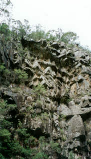
The rock formations in the Ettrema Gorge walls are spectacular
Alternatively, take the HMAS Albatross turn-off from Nowra, veer left at the roundabout, and follow this for about 5km. Turn on to the Nowra-Braidwood Rd on the right just before the Nowra airport.
Either way, take the Tolwong Rd turnoff (Nerriga MGA398142) to the north, signposted as Touga Rd. This is dirt but reasonably good quality. The Jumps is reached about 7km down the road. To get to Quiera Clearing, continue on 3km to a junction and take the right fork. Quiera Clearing is 4km past the junction. This is private property. Drive through the clearing and park on the right hand side beyond the private property (signposted).
Track notes
From 01 Jan 2000, last checked 19 Feb 2023
Map references are to the Nerriga and Touga sheets.
Most access to the Ettrema area is via the Tolwong Rd. There are a number of more commonly used routes on this, the western side of the wilderness.
Bullfrog Creek is a reasonably straightforward, although scrubby way to Ettrema Creek. The usual starting point is near The Jumps. It is very slow at the top, but opens out nicely near the bottom. The spur and side creek at MGA405197 can avoid some of the scrub at the top, although some good route finding and scrambling may be necessary.
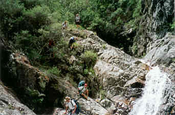
One of the first scrambling sections in Myall Creek
Myall Creek is probably the most commonly used entry. One option is to skirt the private property around Quiera Clearing and get into the minor gully that joins Myall Creek at MGA421257. Like Bullfrog, the top of Myall Creek is scrubby, but there is a pad for much of this. The creek then becomes bouldery, before the main cascades are reached at around MGA422249. Scrambling is required, and a rope for pack lowering may be needed. There are two larger waterfalls of about 10m lower down, one at MGA427244 and one at MGA433243, both of which can be bypassed by exposed sidling on narrow ledges to the true left.
Transportation Spur is a common exit. It is quite straightforward, although steep at the bottom. The pass at the top starts on the right side of Pardon Point, and passes through a gap to the left side where it is easy to scramble out. Follow the ridge back to the road. The green areas involve heavy scrub, and can be very slow going. An alternative is to contour back to Quiera Clearing, which stays below the thick scrub.
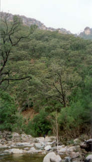
Ettrema Creek is quite open near its junction with Jones Creek
Howards Pass is another reasonably straightforward route, although the pass is incorrectly marked on the second edition map. Climb Barrons Crown, and continue up the ridge. At the top keep to the right of the ridge line (north) and you will be in a steep creek bed. The pass is just on the south side of the creek bed (not north, as indicated on some maps), with a small scramble through the top line of cliffs. The tops are very scrubby, and a compass bearing of 280 degrees will get you to Tullyangela Creek. Follow the creek to the clearing (private property).
Campsites in the gorges can be a bit ephemeral. They come and go depending on use and recent floods, so information may be out of date.
In Ettrema Creek itself, there are good campsites on the two sets of bends in Ettrema Creek downstream of the Bullfrog junction. There was a good campsite at the Myall Creek junction, though fire and flood has altered it for the worse - there may no longer even be space for a couple of tents. Other possible campsites include: at the Jones Creek junction; at a sandy bend at around MGA456266; opposite Gallows Gully; and at the Tullyangela Creek junction.
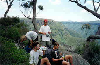
Walkers take a break on Barrons Crown
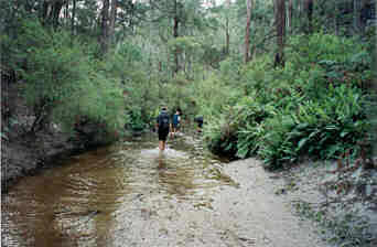
Ettrema Creek is excellent walking between Bullfrog Creek and Myall Creek. It is mainly rocky open slabs with rock-hopping on boulders, and occasional large pools for swimming. The water levels can be quite variable, and wading is likely in a few places. Experienced scramblers may be able to keep their feet dry most of the time. Just before Myall Creek you start running into weeds in Ettrema Creek, presumably from the grazing on the tops at Quiera Clearing. Downstream from Myall Creek it is similar, with rock hopping and intermittent large pools. Past Jones Creek, Ettrema Creek widens, the rocks for rock hopping get further apart, and some wading is almost inevitable. The last few kilometres to Tullyangela Creek are relatively easy going.
Jones Creek is well worth a visit. The walking is excellent, there are some beautiful cascades and waterfalls, and the mines are worth a look if you remember a torch. There are two main sets of cascades in the bottom section of the creek at MGA449241 and MGA449235. The waterfalls need a bit of scrambling to bypass, and one of the upper ones may be too slippery to ascend/descend if water levels have been up. Just beyond these, at MGA449233, are Tinga Falls. These are the biggest set of falls in the creek, at around 60m high. This is about as far as most parties would come.
Heading up Tullyangelo Creek
Water quality cannot be completely guaranteed, particularly in and below Myall Creek due to grazing on the tops. Best is to take it from the smaller side creeks where possible. Ettrema Creek above Myall Creek is probably fine. Water from Jones Creek is best avoided due to leaching from the silver mines near creek level.
A good two day walk starts by descending Myall Creek from Quiera Clearing and camping at the junction with Jones Creek. On the following day, make your way downstream to Gallows Gully and exit up Transportation Spur.
The walk above can be extended to a three day trip by continuing downstream on the second day to the Tullyangela Creek junction and camping. A side trip to Jones Creek is worthwhile. On the final day, exit via Howards Pass and make your way to Tullyangela Clearing from where you can can walk back to Quiera Clearing if you have not arranged a car shuffle.
Another three day walk descends Bullfrog Creek camping at 422202. On the second day, make your way downstream to the Myall Creek junction, and camp (though it may be worth pushing on to Jones Creek if the Myall Creek campsite is unsatisfactory). Exit up Myall Creek on the final day.
For further information on the area, see the references below.
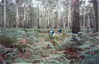
A sea of ferns at the top of Tullyangelo Creek
Related walks
Pigeon House Mountain
Time: 3 hrs Distance: 6 km Fitness: E Skill: E Ascent: 490 m
A steep but rewarding climb to this signature peak
The Castle
Time: 10 hrs Distance: 11 km Fitness: M Skill: M Ascent: 810 m
A long and challenging climb to the summit of this cliff-ringed peak, with spectacular views
Mt Talaterang
Time: 8 hrs Distance: 20 km Fitness: M Skill: M Ascent: 440 m
A challenging walk to one of the iconic peaks of the Budawangs
Corang River
Time: 2 days Distance: 27 km Fitness: M Skill: M Ascent: 360 m
A moderate overnight walk visiting the beautiful Corang River and spectacular Corang Arch, in the Budawang Wilderness
Caoura Ridge
Time: 2 days Distance: 32 km Fitness: EM Skill: EM Ascent: 300 m
Relatively easy walking to a variety of great lookouts around the Shoalhaven
Personal reports
29/12/2021-01/01/2022 - Jones Creek: Tolwong Rd - Coolumburra Trig - Ettrema Creek - Jones Creek Trail (C) - Jones Creek - Ettrema Creek (C) (C) - Ettrema Creek - Myall Creek - Churinga Head - Tolwong Rd (report)
26-28/01/2019 - Ettrema Creek: Tolwong Rd - Bullfrog Creek - Ettrema Creek (C) - Myall Creek (C) - Quiera Clearing [SBW] (photos)
13-14/11/2010 - Ettrema Creek: Quiera Clearing - Myall Creek - Ettrema Creek - Jones Creek (C) - Transportation Spur - Quiera Clearing [SBW] (photos)
11/02/2005 - Ettrema Creek: The Jumps - Bullfrog Creek (C) - Ettrema Creek - Myall Creek (C) - Churinga Head - Myall Creek (C) - Jones Creek - Gallows Gully (C) - Transportation Spur - Quiera Clearing - The Jumps (report | photos)
01-03/01/2000 - Ettrema Creek: Quiera Clearing - Myall Creek - (C) Ettrema Creek junction - Sentry Box Canyon - Barrons Crown - Howards Pass - Tullyangela Creek - Tullyangela Clearing (report | photos)
Links
 Bushwalking In The Budawangs, Ron Doughton
A variety of interesting and challenging walks in Morton and Budawang National Parks
 Ettrema Creek - Danny Yee
Trip report of a walk down Myall Creek to Ettrema Creek and up Transportation Spur