| Time: | 4 hrs |
| Distance: | 10 km |
| Fitness: | E |
| Skill: | E |
| Ascent: | 120 m |
| Maps: | LPI Broken Bay 9130-1N 1:25000 |
| Notes: | Print-friendly notes (opens in new window) |
Introduction
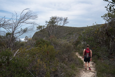
Descending off Bombi Moor
The Bouddi Coastal Walk follows the coast from Macmasters Beach to Putty Beach. The scenery is quite variable, from beach walking to exposed moors, open forest to rainforest and rock platforms.
While the walk can be done at any time of year, it is best in the warmer months to allow for swimming at the various beaches along the way.
The walk can be done in either direction. However, the north-eastern section of the walk is quite exposed. On warmer days, it is best to start at the eastern end so you are not walking that section in the heat of the day. The notes below describe the walk from east to west.
The track is generally well signposted, though attention does need to be paid to the map and route at times.
Access
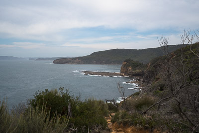
Views from Bouddi Spur to Gerrin Point and Box Head
The logistics of the walk are a bit of a challenge. During the week there are occasional buses along the Scenic Rd, but on the weekend there are none. So essentially a car shuffle is needed between Putty Beach and Macmasters Beach.
The walk starts at the Surf Life Saving Club at the southern end of Macmasters Beach.
Another car needs to be left at Putty Beach, about 15 min (10km) drive away. Parking at Putty Beach costs $7. If you don't want to pay for parking, there is a rough unmarked track that leads up to Jacqueline Ave from the camping area at Putty Beach, and you could leave a car in the streets around there.
Track notes
From 20 Oct 2018, last checked 20 Oct 2018
Head along Marine Parade for about 50m to where a footpath leads up between houses to Macmaster Parade, and turn left. At the end of Macmaster Parade, another sealed path leads through a beautiful section of open coastal forest to Beachview Esplanade opposite Ocean Dr. Turn left on to Beachview Esplanade and follow it to the end.
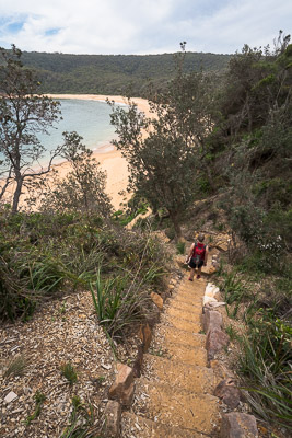
Descent to Maitland Bay
Continue along the fire trail, the Mourawaring Moor Trail, passing the Second Point Trail and the 72 Trail on your left.
There is an optional out-and-back detour of about 1.2km total to the end of the Second Point Trail, where a short foot track leads down to a rock platform above the Pacific Ocean, with great views.
The Mourawaring Moor Trail then turns sharp left, passing another trail on the right, before ending. A steep and rough foot track leads down to secluded Little Beach, which has a small camping and picnic area.
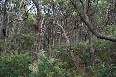
Open coastal forest past Maitland Bay
Follow the fire trail up the hill out of Little Beach for 300m and turn left on to a sealed path, signposted Bouddi Coastal Walk, to Maitland Bay, Mount Bouddi and Putty Beach. After another 400m or so, the foot track emerges into a large clearing at a 4-way intersection with three fire trails. Keep right following the Bouddi Coastal Walk signs, along the Bombi Moor Trail.
Both the 81 Trail (1.4km return) and the Third Point Trail (1.5km return) offer optional out-and-back detours to the cliff edges for more good views.
Otherwise, the Bombi Moor Trail ends at a clearing, and a foot track descends to Cave Creek, where you can rock hop down to the bay if you like.
Continuing up the other side, the track makes its way out to the cliffs, before arriving at a junction with the Mt Bouddi Track, where you keep left. Continue down to the saddle, and then right and down a steep set of stairs to the remote beach of Maitland Bay. Maitland Bay is a sheltered beach, and a great spot for a dip on a warm day. Note that the beach is unpatrolled, so be careful.
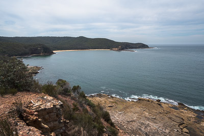
Gerrin Point, looking back to Maitland Bay
Head along to the western end of the beach, and look for a small sign marking where the Maitland Bay Track leaves the beach. Head up the track a few minutes, and then turn left at the signposted junction on to the Bouddi Coastal Walk. This track undulates through a variety of coastal forest and vegetation to a fenced lookout near Gerrin Point. About 100m before the lookout, an unmarked side track leads up to Bullimah Lookout.
About 5 minutes beyond the lookout, a boardwalk detours off for a short side trip to Bullimah Beach. Otherwise, continue along the track, which follows the cliffs, for another 500m to Putty Beach.
Related walks
Putty Beach and Maitland Bay
Time: 3 hrs Distance: 9 km Fitness: EM Skill: EM Ascent: 140 m
A good year round walk to a couple of nice beaches.
Links
 Bouddi coastal walk - NPWS
Brief summary of the walk and map