Overview
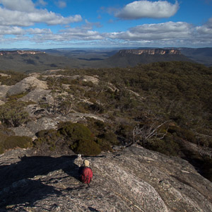
Sweeping vistas of pagodas in front of Pantoneys Crown, Gardens of Stone National Park
Gardens of Stone National Park is a medium-sized national park of around 15,000 ha, consisting of three separate parts, around 40km north of Lithgow and 130km NW of Sydney. It protects a landscape of cliffs, stunning rock pagodas and slot canyons, hence the name. It is part of the Greater Blue Mountains World Heritage Area, and adjoins Wollemi NP (to the east) and Mugii Murum-ban SCA (to the north).
The northern part of the park covers the spectacular and distinctive Pantoneys Crown, the valleys of Red Rock Creek, Crown Creek and Coco Creek, and the western escarpment of the Wolgan-Capertee Divide; the south-eastern part protects the cliffs and canyons of the Newnes Plateau, while the small middle section covers Donkey Mountain, an island of rock rising out of the Wolgan Valley. Being further north and west than the Blue Mountains, the area receives much less rainfall, and even larger creeks can dry up after dry spells.
Access
Because of the number of different sections, the park has a range of accesses.
The area around Pantoneys Crown can be accessed from the north, off the Glen Davis Rd, or more commonly from either the fire trail that leaves the Wolgan Rd 7.7km after the turnoff from the Castlereagh Highway at Lidsdale, or the Moffitt Trail that leaves the Castlereagh Highway at the railway crossing at Ben Bullen. Both of these fire trails are rough at the best of times, and may not be 2WD accessible, even in good weather.
In the middle section of the park, Donkey Mountain is accessed off the Wolgan Rd, on the way to Newnes, just before the Emirates Resort and Barton Creek ford.
In the south-eastern section of the park, the main access is via the Sunnyside Ridge Road (fire trail) that leaves the Glowworm Tunnel Road at the Bungleboori Camping Area.
The best views of the Gardens of Stone by car can be found at Pearsons Lookout, on the Castlereagh Highway, 3km south of Capertee.