| Time: | 4 hrs |
| Distance: | 10 km |
| Fitness: | EM |
| Skill: | EM |
| Ascent: | 450 m |
| Maps: | LPI Katoomba 8930-1S 1:25000 |
| Sketch maps: | Sketch map 1 PDF |
| Notes: | Print-friendly notes (opens in new window) |
Introduction
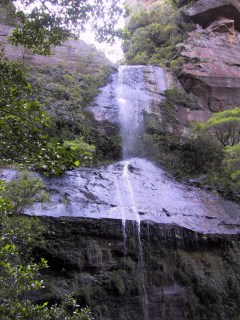
Bonnie Doon Falls in Nellies Glen
Nellies Glen lies at the Katoomba end of the Six Foot Track, the old bridle trail that led from Katoomba to Jenolan Caves. This loop walk descends the gully of Nellies Glen and returns via the Devils Hole, an impressive cleft topped by a massive boulder.
The walk is best in spring and autumn. Nellies Glen and the Devils Hole are quite cool and shady and can be chilly in winter.
Access
From Scenic World at Katoomba, drive south along Cliff Drive. You pass a number of lookouts on your left, and then pass Glenraphael Dr. You pass another lookout (Narrow Neck Lookout) before meeting Narrow Neck Rd. Keep left on Cliff Dr here and park your car at the first open area on the left. There is a sign here indicating the start of the Devils Hole Track.
Alternatively, you can walk from Katoomba Station if you have caught the train. In this case you would be best off starting the loop at Stuart St, or the Explorers Tree. Either of these is about 2.5km from the station.
Also, there are buses to Katoomba Golf Course or Scenic World, which would be shorter walks to join the loop at the junction of Cliff Rd and Narrow Neck Rd.
Track notes
From 04 May 2003, last checked 22 Apr 2018
Walk up Cliff Dr to Narrow Neck Rd and turn left. After 700 m take a left down Stuarts Rd and follow it to the end. Turn left at the T-junction, and right on to a foot track at a sign saying "Cliff Walk and Look Out". After 300 m there is large cairn, marking a short side trip on the left down to Therabulat Lookout, with good views over the Megalong Valley. [Note that this track is incorrectly marked on current (2018) topographic maps.]
Continuing along the main track [also incorrectly marked on current topographic maps] it crosses a couple of small creeks on bridges and climbs up to the ridge, where a minor track branches off to the right. Continue on the main track down to another creek in a pretty valley, and climb up the hill to the next ridge and a major track at a T-junction. After a quick visit to Norths Lookout, down to the left, retrace your steps and walk up the other branch of the track to a fire trail junction. This is the intersection with the Six Foot Track, and a couple of large signs indicate so.
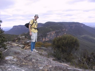
Views of Narrowneck from the top of the Devils Hole
Not far from here stands the remains of the Explorers Tree, reportedly marked by Blaxland, Lawson and Wentworth on their historic first crossing of the Blue Mountains. If you are desperate to see the Explorers Tree, it is about a 1.6 km detour there and back (800 m each way). Take the right branch, which leads up to Nellies Glen Rd after 500 m. Turn right, the Explorers Tree monument is on the corner after about 200 m.
Otherwise take the left branch, which descends Nellies Glen. The track gets very steep, dropping between high cliff walls, and there are widely spaced wooden steps for much of the next section. The track is washed away in a couple of places, and some scrambling over boulders is necessary. As you reach and cross Megalong Creek, the final cascade of Bonnie Doon Falls (Ethal Fall) is visible a short distance upstream. There is no track to the base of the falls, but you can scramble up boulders to reach them.
The track soon flattens out and the walking is pleasant along the left side of the valley above the creek. There are a couple of campsites in this section. The track gets wider and becomes a fire trail again, flattening further as it heads into the more open valley.
Soon you reach a junction with another fire trail in from the left - this is the Water Board Road toward Dicksons Ladders (now non-existent. A sign states as much). Follow this fire trail for about 10mins to where a faint track branches off left at MGA478646 - there may be a cairn here. The track dips down to cross a small creek, then climbs steadily up to the cliff line, generally heading north east. Eventually you reach a point where you can see an obvious cleft in the cliff line - head up at this point. This is the Devils Hole, and a huge boulder jammed in the cleft above you marks this point.
When you reach the top of the cleft there are tracks both left and right. They do all lead back to the road, but the right hand one is the most straightforward to follow, though more adventurous types may want to try the left branch. There is a good lookout on a track off the right hand branch, just as the track flattens out after climbing out of a gully. Otherwise, keep on the main track that takes you back to the road, and then right to your car.
Related walks
Mitchells Creek
Time: 8 hrs Distance: 16 km Fitness: M Skill: MH Ascent: 480 m
An interesting walk exploring one of the lesser known passes of Narrow Neck
Personal reports
22/04/2018 - Nellies Glen and the Devils Hole: Cliff Dr - Narrow Neck Rd - Stuarts Rd - Cliff Walks - Norths Lookout - Nellies Glen - Six Foot Track - Water Board Rd - Devils Hole Track - Devils Hole - Cliff Dr (photos)
12/09/2009 - Katoomba Short Walks: Olympian Rock; Stuart St - Therabulat Lookout - Nellies Glen - Bonnie Doon Falls - return; Devils Hole lookouts (photos)
04/05/2003 - Nellies Glen and Devils Hole: Cliff Dr - Narrow Neck Rd - Explorer's Tree - Nellies Glen - Megalong Valley - Devils Hole (report)