| Time: | 2 hrs |
| Distance: | 5 km |
| Fitness: | E |
| Skill: | EM |
| Ascent: | 60 m |
| Maps: | LPI Wollangambe 8931-2S 1:25000 |
| Notes: | Print-friendly notes (opens in new window) |
Introduction
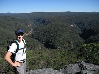
Looking out over the Wollangambe River valley
Eroding sandstone rock can form some amazing patterns. Deep grooves in the rock create a mosaic-like pattern that can stretch across a rocky platform. The Tesselated Pavements, north of Mt Irvine, in the Blue Mountains, are one excellent example of these. This relatively short walk visits those pavements, as well as superb viewpoints over the Wollangambe River and Bowens Creek valleys.
Access
The walk starts just beyond the end of the road at Mt Irvine. Mt Irvine is a small hamlet reached by a winding road from Mt Wilson. It has no shops or services.
Take the Mt Wilson turnoff from Bells Line of Road, and turn left at the top of the steep hill 400m after the sharp hairpin bend. Drive through Mt Wilson and turn left at the T-intersection at Mt Irvine Rd. Follow this for about 9km to where the Bowens Creek Road continues straight ahead. Ignore this and veer left on to Mt Irvine Rd, also ignoring another turn off to the left just after the intersection. After a further 3km you should be at the end of the road.
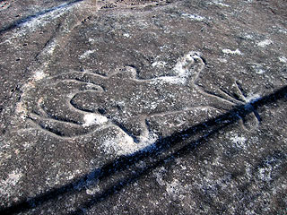
Aboriginal engraving on the sandstone platform
Pass through the gate on the right on to a service road. Pass a house on your right after 300m, and stay close to the fence line on your left, driving quietly. At the first fork in the firetrail, take the right branch heading downhill. Follow this fire trail about 200m down to a clearing and park here. (Note the firetrail was recently graded at the time of writing, the last section might suffer erosion). Alternatively you could could park back on the sealed road, which would add about 800m each way.
Track notes
From 09 Sep 2007, last checked 26 Oct 2014
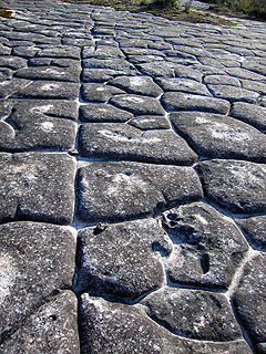
The Tesselated Pavements
After parking at the clearing, ignore the firetrail that heads west down to the left. The walk starts on the NNW corner of the clearing where you should pick up a faint track heading up the ridge and over the small knoll. The track is a little overgrown in places but should be easy enough to follow. After about 10 min it drops into a saddle and climbs up to a small cliffline.
Traverse left below the mini cliffline until you can easily get up the gully. Note the lyrebird nest in the cave in the cliffline.
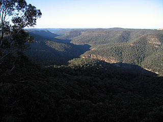
Bowens Creek valley stretches off in the distance
The track continues through open forest across the top of Tesselate Hill, although it can be hard to pick up in places. If you lose it, simply head north, keeping to the top of the ridgeline. It is worth detouring a short distance off track to the cliff edges on either side. From the cliff tops to the west you can see all the way down into the Wollangambe River as it does a large horseshoe bend below. On the east side there are great views over Bowens Creek. Both are canyons higher in their catchment, and have incised deep gorges through the soft sandstone. Continuing along the track, it descends down to a massive open rock platform. The rock is deeply grooved and patterned - these are the Tesselated Pavements.
From the western side of the pavements there are more excellent views of Bowens Creek, and of the long ridge running out between the Wollangambe River and Bowens Creek. If you look around the pavements you may be able to find aboriginal carvings and sharpening grooves. If you find them, look, but please don't touch.
After a break return to the car the way you came.
Personal reports
25-26/10/2014 - Short Creek Canyon: (report | photos)
09/09/2007 - Tesselated Pavements: Mt Irvine - Tesselated Pavements - Wollangambe River - and return (report | photos)
Links
 Tesselated Pavements - Dingo Gap Gallery
Notes and pictures from a walk to the Tesselated Pavements