Overview
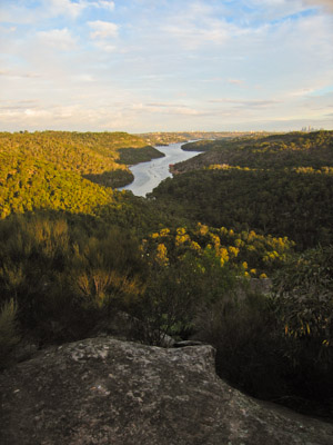
Bantry Bay in the late afternoon from Bluff Lookout, Garigal National Park
Access
Access to the southern section of the park is via numerous roads in the Roseville, Lindfield, St Ives, Belrose, Davidson and Killarney Heights areas. The picnic area is reached off Warringah Rd on the east side of Roseville Bridge. The northern section of the park abuts Forest Way in Belrose, Mona Vale Rd in Terrey Hills, and can be reached by fire trails off Morgan Rd in Belrose, and Wakehurst Parkway near Narrabeen Lakes.
Activities
Bushwalking
Numerous short tracks run alongside most of the major creeks in the southern section of the park. It is possible to walk from Seaforth at the southern end all the way to Mona Vale Rd at the northern end, and there are many entry and exit points to both sides of Middle Harbour Creek along the way. The northern section of the park is less developed. It is possible to walk from Morgan Rd down to Narrabeen Lakes, one route via the ridge, and another dropping into Deep Creek along the way.
Canoeing/Kayaking
Canoeing in Middle Harbour and Middle Harbour Creek is particularly pleasant. With small craft it is possible to go as far up as Rocky Creek, and possibly a little further. Some of the tributaries such as Gordon Creek and Carroll Creek are also navigable for short distances. The waterways in the northern section of the park are too shallow and rocky for watercraft, although the nearby Narrabeen Lakes offers plenty of paddling.
Climbing
The 2002 changes to NPWS legislation disallow climbing (and other adventure activities) in a national park unless the plan of management (PoM) specifically allows it, or you have NPWS permission. There is no mention of allowing climbing in the Garigal NP PoM. This presumably affects Crumbly, a bouldering area in Killarney Heights, and Elanora Heights, a sport climbing crag off Amaroo Ave in Elanora Heights, both inside the park. Just outside the park are a number of good climbing areas around Narrabeen, plus some crags above Middle Harbour such as Sissy Crag, Castle Cove and Middle Cove.
Mountain Biking
In general, mountain biking is permitted on fire trails, but not on walking tracks. Some fire trails are being regenerated, so it is not always clear where mountain biking is permitted. The Cascades area, below Acron Oval in St Ives has worthwhile mountain biking. Also, two of the best areas for mountain biking in Sydney are located near the edge of the park at Oxford Falls and Red Hill. These are a mix of fire trails and single track, of all levels of difficulty. Some of the tracks in the Oxford Falls area may in fact cross into the park, and the status of these is not clear.
Walks
Lindfield to Gordon
Time: 3.5 hrs Distance: 12km Fitness: E Skill: EM Ascent: 150m
A short walk along a beautiful and rarely visited stretch of Middle Harbour in the heart of Sydney
Roseville to Lindfield
Time: 4 hrs Distance: 11km Fitness: E Skill: E Ascent: 100m
A pleasant walk along the creeks and foreshores of Middle Harbour
Links
 Garigal National Park - NPWS
A summary of information about Garigal National Park, including information on camping facilities, wheelchair access, visitor centres, animal species list and plan of management.