| Time: | 6 hrs |
| Distance: | 16 km |
| Fitness: | MH |
| Skill: | EM |
| Ascent: | 700 m |
| Maps: | LPI Warrumbungle National Park Tourist Map 1:40000 |
| LPI Tooraweenah 8635-S 1:50000 | |
| Sketch maps: | Sketch map 1 PDF |
| Notes: | Print-friendly notes (opens in new window) |
Introduction
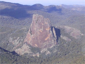
Crater Bluff from Bluff Mountain
The face of Bluff Mountain is the highest of the cliffs in the Warrumbungles. This walk takes you to the top of the cliffs, as well as providing views of the face on the way out. There are also great views of other Warrumbungles peaks from various points on the walk.
The Warrumbungles are very hot in summer, so the best time to visit is in the cooler months, between April and September. The only water on the walk is at Balor Hut, and if you are relying on this, you will need to confirm whether there will be any with the visitor centre.
Access
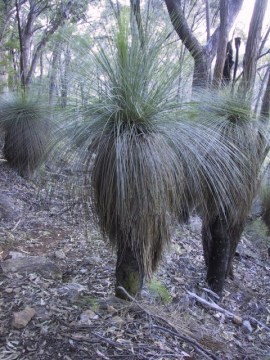
Grass trees on the climb up to Bluff Mountain
Track notes
From 11 Jun 2004, last checked 04 Oct 2014
From the Pincham Car Park, head along the easy walking track along Spirey Creek. Only a short way in, you pass Camp Pincham, which is a walk-in camp site for those looking to get away from the car but not walk far.
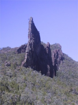
The Breadknife from near Balor Hut
After crossing Spirey Creek, the track shortly reaches the junction with West Spirey Creek, which is the return route for later in the day. Continue along the main track, which is mostly paved. Pass a turnoff to Spirey View lookout, and continue up the steep track on a long switchback up to Sreng Boss. Along this section you start getting views of the Breadknife and Belougery Spire. At the top of the main climb, you hit a set of metal stairs. Turn right along the Dagda Short Cut, though if you wanted to make the walk harder (adds an extra 120m of climbing), you could continue left up to the Grand High Tops. Either way, you soon reach Dagda Saddle.
From Dagda Saddle, continue west along the track towards Dows Camp. Dows Camp is a pleasant camping area set at the junction of the main track with that up to Bluff Mountain.
Belougery Spire from the track to the Grand High Tops
The track up to Bluff Mountain starts off clearly, climbing steadily up past the masses of grass trees growing on the slopes. Once on the summit ridge, it becomes harder to follow, as it crosses rocky outcrops. This section of the path is not marked. Generally speaking keep to the top of the ridge, as you head north. There are a couple of places where you may need to scramble using hands and feet. Note any tricky sections for your return trip. Soon you reach the rocky summit, with great views over the northern part of the park.
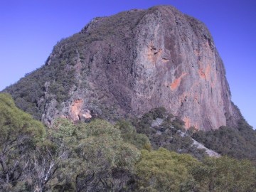
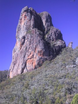
The imposing face of Bluff Mountain
After enjoying the vista, return to the track junction at Dows Camp. Continue along the main track along Dows High Tops. It is a bit under an hour's walk to Ogma Saddle, or Gap, though just before Ogma is an unmarked saddle. There are plenty of views of the impressive face of Bluff Mountain as you proceed along this section of track.
From Ogma Gap, take the track to the north that leads down into the top of West Spirey Creek. This descends steeply at first, and then more easily. About an hour's walk brings you back to the bridge at the main Spirey Creek track, and it is only about 20 minutes back to the car.
Related walks
Mt Exmouth
Time: 2 days Distance: 26 km Fitness: M Skill: E Ascent: 1230 m
While its appearance is not as dramatic as that of some of the other Warrumbungles peaks, the views from the summit of Mt Exmouth are superb, looking out over the rest of the park.
Belougery Split Rock
Time: 3 hrs Distance: 7 km Fitness: E Skill: EM Ascent: 350 m
A short but interesting walk, with some scrambling and great views of the Grand High Tops from the summit
Links
 Warrumbungle National Park, Peter Fox
This slim guide has a good summary of the natural history and human history of the park, and a lift out section with most of the major walks in the park in detail.