| Time: | 3 hrs |
| Distance: | 9 km |
| Fitness: | EM |
| Skill: | E |
| Ascent: | 280 m |
| Maps: | LPI Ben Bullen 8931-4S 1:25000 |
| Sketch maps: | Sketch map 1 PDF |
| Notes: | Print-friendly notes (opens in new window) |
Introduction
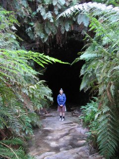
The entrance to the Glowworm Tunnel
In 1906 and 1907 the Wolgan Valley Railway was built to haul oil shale from the mines at Newnes up to the main railway at Clarence. It was an amazing piece of engineering for its day. It ran over 30 miles (50km), through two tunnels and dropped almost 700m from the top of the ridge to the Wolgan Valley at a steep gradient. The railway has been long since abandoned, but the tunnels remain. The Glowworm Tunnel is the second of these old tunnels. The long steady curve means that the middle of the tunnel is pitch black, and the walls are always damp with water, ideal conditions for glowworms.
The walk follows the railway embankment up under the cliffs to the tunnel, and returns via the Old Coach Road back into the valley. It can be done at any time of year, although the climb can be fairly hot in summer. You will need a torch for the tunnel itself, as it is completely dark in the middle.
Access
Track notes
From 11 Jun 2001, last checked 25 Mar 2005

The view from inside the tunnel
Cross the ford and head up the hill opposite on the track until you reach the old Wolgan Valley Colliery. Turn left for a few hundred metres until you meet a junction. This is the start of the loop. You can go either direction, however we will assume that you head right.
For the next 3km, the track follows the old railway embankment. The old railway traversed the base of the cliffs above the valley, and the amount of work to cut it into the cliffs was enormous. It is amazing to think that it was built in just 13 months, considering what time a similar project would take to complete today. Here and there you can see old sleepers, although the tracks themselves have long since been removed and reused. There are a couple of washout gullies that need to be crossed on the way. Just before reaching the tunnel, the track heads up a gully into a canyon which narrows until you get to the tunnel itself.
You will need a torch in the tunnel. If you have forgotten one, your best bet is to stay to the left, as there is a track on that side for most of the way. However, there is running water in the tunnel and your chances of getting wet feet are high.

Looking back into the tunnel from the downstream end
The tunnel is around 400m long, and curves steadily to the right. Please keep noise and light to a minimum, particularly in the middle section, as it disturbs the glowworms. Don't shine your torch directly on the glowworms.
If you have time, when you exit the tunnel, you can take a right turn and follow the creek through Bells Grotto Canyon. However, you will then have to either retrace your steps, or pass through the tunnel once more.
Once through the tunnel continue for about 300m until you reach a turnoff to the Pagoda Track on your left. As its name implies there are lots of interesting pagoda rock formations visible from the track. Follow this for about 1km up over a saddle and down to the junction with the Old Coach Rd, and turn left. The Old Coach Rd used to be the main road into Newnes. It is somewhat frightening to think of the old vehicles going down that road, as it is narrow with a steep drop off the right hand side.The Old Coach Rd eventually leads back to where you started the loop. Follow the trail back down the hill to the ford where you left your car
Related walks
Newnes to Rocky Creek
Time: 2 days Distance: 25 km Fitness: EM Skill: EM Ascent: 140 m
A long day walk or easy two day walk down the Wolgan. Camping is possible at Rocky Creek, or head up Rocky Creek to the junction with Deanes Creek
Newnes to Annie Rowan Creek
Time: 3 days Distance: 41 km Fitness: M Skill: EM Ascent: 240 m
A harder two day or relatively easy three day walk down the Wolgan. A camp can be set at Rocky Creek, with a day walk to Annie Rowan Creek.
Pipeline Track
Time: 2 days Distance: 20 km Fitness: M Skill: EM Ascent: 800 m
A good walk following the old oil shale pipeline from Newnes to Glen Davis. Great views of both the Wolgan and Capertee Valleys.
Personal reports
11/06/2001 - Glowworm Tunnel: from Newnes Rd (report)
Links
 Newnes Services Home Page - Allan Watson
Excellent resource for anyone planning on visiting Newnes, on the western edge of Wollemi
 Bushwalks in the Sydney Region Vol 1 (Edition 4), S Lord and G Daniel
An excellent resource for walkers, with a variety of walks within easy reach of Sydney
Glow Worm Tunnel from Newnes - Hiking the World
Detailed report of the walk with maps and photos
Glowworm Tunnel walk - Lithgow Tourism
A good general description of the Glowworm Tunnel walk
Glowworm Tunnel walk - Info Blue Mountains
A reasonable description of the walk, with good information on glowworms and the tunnel itself
Glowworm Tunnel - SleepWhenWeAreDead
Brief notes and pictures for the Glowworm Tunnel walk