Overview
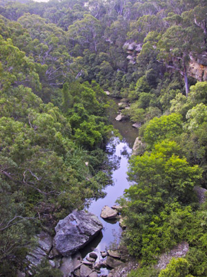
The upper reaches of the Lane Cove River, from De Burghs Bridge, Lane Cove National Park
Access
The road entry points to the lower section of the park are at Lady Game Drive in Chatswood, and from Lane Cove Rd in Ryde. Note that due to the construction of the Chatswood to Epping rail link, there is currently no road access between the Lane Cove Rd entrance and the Lady Game Drive entrance. There are locked gates at the weir (at the Lady Game Drive entrance) and again about 500m further up the road.
The Lady Game Drive entrance can be reached by car, by the 259 or 545 bus from Chatswood Station, or a 1.5km walk from the same station. The Lane Cove Rd entrance can be reached by car, by the 545 bus from Chatswood Station or the 292 bus from Wynyard or St Leonards Stations, or by a 1km walk from Macquarie Centre bus interchange.
The upper section of the park can be reached by walking tracks and cycle tracks that lead in off various back streets from the suburbs of Pymble, Turramurra, Wahroonga, Thornleigh, Pennant Hills, Beecroft and Macquarie Park.
Activities
Bushwalking
Canoeing/Kayaking
Mountain Biking
Walks
Riverside Loop
Time: 3 hrs Distance: 11km Fitness: E Skill: E Ascent: 50m
An interesting loop walk with a variety of flora and fauna to be seen
Chatswood West to Thornleigh
Time: 5 hrs Distance: 14km Fitness: EM Skill: E Ascent: 160m
An easily accessible walk by public transport in the bushland of Sydney's northern suburbs
Hunters Hill to Chatswood West
Time: 5 hrs Distance: 17km Fitness: EM Skill: E Ascent: 50m
A pleasant mix of street and bush walking through parts of Sydney's lower North Shore