Overview
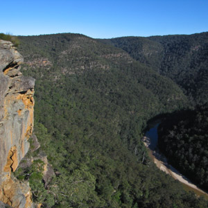
Looking down from the cliffs above the Colo River, Wollemi National Park
Access
Activities
Bushwalking
Canyoning
Canoeing/Kayaking
Mountain Biking
Liloing
Walks
Newnes to Rocky Creek
Time: 2 days Distance: 25km Fitness: EM Skill: EM Ascent: 140m
A long day walk or easy two day walk down the Wolgan. Camping is possible at Rocky Creek, or head up Rocky Creek to the junction with Deanes Creek
Newnes to Annie Rowan Creek
Time: 3 days Distance: 41km Fitness: M Skill: EM Ascent: 240m
A harder two day or relatively easy three day walk down the Wolgan. A camp can be set at Rocky Creek, with a day walk to Annie Rowan Creek.
Glowworm Tunnel (from Newnes Rd)
Time: 3 hrs Distance: 9km Fitness: EM Skill: E Ascent: 280m
A easy walk along an historic railway track, and one of the best daytime displays of glowworms around.
Pipeline Track
Time: 2 days Distance: 20km Fitness: M Skill: EM Ascent: 800m
A good walk following the old oil shale pipeline from Newnes to Glen Davis. Great views of both the Wolgan and Capertee Valleys.
Mountain Lagoon Loop via Colo Meroo and Tootie Creek
Time: 2 days Distance: 29km Fitness: MH Skill: M Ascent: 520m
A challenging river walk along the lower reaches of the Colo River.
Crawfords Lookout to Dooli Creek
Time: 2 days Distance: 21km Fitness: M Skill: MH Ascent: 460m
A challenging walk through some of the best scenery in the upper Colo River.
Canoe Creek
Time: 4 hrs Distance: 6km Fitness: EM Skill: EM Ascent: 400m
A relatively easy route to the magnificent Colo River, with good swimming and the option of camping.
Bob Turners Track
Time: 2 hrs Distance: 6km Fitness: E Skill: E Ascent: 280m
One of the easiest routes to the Colo River. A lovely pool and beach make it a delightful spot for swimming, although it is a decent climb in and out.
Crawfords Lookout
Time: 2 hrs Distance: 8km Fitness: E Skill: EM Ascent: 240m
A short walk to a spectacular lookout over Wollemi Creek and the upper Colo River.
Colo Meroo
Time: 2 days Distance: 24km Fitness: EM Skill: EM Ascent: 580m
Good views of the Colo River on the way to this excellent camp ground by the river itself
Tootie Creek (T3 Track)
Time: 4 hrs Distance: 6km Fitness: M Skill: EM Ascent: 500m
A steep but short and spectacular walk to the Colo River at its junction with Tootie Creek
Links
 Discovering the Colo Wilderness on Foot, Anthony Dunk
A useful little book with a number of less well known walks in the one of the state's biggest wilderness areas.
 Newnes Services Home Page - Allan Watson
Excellent resource for anyone planning on visiting Newnes, on the western edge of Wollemi
The Colo Gorge - Anthony Dunk
A useful personal site with varied information on aspects of the Colo River area in Wollemi NP
Wollemi National Park - NPWS
A summary of information about Wollemi National Park, including information on camping facilities, visitor centres, animal species list and plan of management